photo free
Home Images Vectors Videos

Stock image New Caledonia Map page 3

stock vector Australia and Oceania - map and navigation icons - illustration.

Australia And Oceania - Map And Navigation Icons - Illustration.

Vector, 3.99MB, 6400 × 4774 eps
stock vector Australia and Oceania region vector high detailed map with countries names and national flags

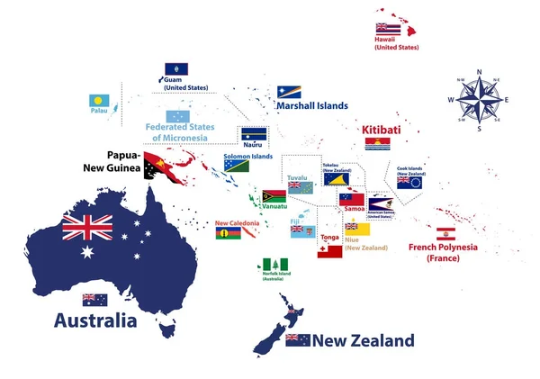
Australia And Oceania Region Vector High Detailed Map With Countries Names And National Flags

Vector, 7.35MB, 8334 × 5852 eps
stock vector vector map of Australia, Oceania and South East Asian countries mixed with their national flags

Vector Map Of Australia, Oceania And South East Asian Countries Mixed With Their National Flags

Vector, 7.57MB, 7292 × 5337 eps
stock vector New Caledonia round sign. Futuristic satelite view of the world centered to New Caledonia. Country badge with map, round text and binary background. Appealing vector illustration.

New Caledonia Round Sign. Futuristic Satelite View Of The World Centered To New Caledonia. Country Badge With Map, Round Text And Binary Background. Appealing Vector Illustration.

Vector, 3.07MB, 5488 × 5488 eps
stock image White Globe - Australia

White Globe - Australia

Image, 5.74MB, 4400 × 5000 jpg
stock image New Caledonia map on  flag drawing ,grunge and retro flag series

New Caledonia Map On Flag Drawing ,grunge And Retro Flag Series

Image, 3.74MB, 7000 × 5000 jpg
stock vector Vector Flat Map of New Caledonia with Name

Vector Flat Map Of New Caledonia With Name

Vector, 0.08MB, 4933 × 3400 eps
stock image New Zealand map

New Zealand Map

Image, 1.07MB, 2400 × 3200 jpg
stock vector Ouvea of New Caledonia Stamp Postal. Map Silhouette rubber Seal.  Design Retro Travel. Seal of Map Ouvea island grunge  for your web site design, app, UI.  New Caledonia. EPS10

Ouvea Of New Caledonia Stamp Postal. Map Silhouette Rubber Seal. Design Retro Travel. Seal Of Map Ouvea Island Grunge For Your Web Site Design, App, UI. New Caledonia. EPS10

Vector, 3.73MB, 2500 × 2500 eps
stock vector New Zealand and southern Polynesia, gray political map with capitals. Solomon Islands, Vanuatu, Fiji, Tonga, Samoa and New Caledonia. Islands in the South Pacific Ocean. English. Illustration. Vector.

New Zealand And Southern Polynesia, Gray Political Map With Capitals. Solomon Islands, Vanuatu, Fiji, Tonga, Samoa And New Caledonia. Islands In The South Pacific Ocean. English. Illustration. Vector.

Vector, 2.28MB, 6000 × 9000 eps
stock image New Caledonia outlined on a Pale colored elevation map with lakes and rivers

New Caledonia Outlined On A Pale Colored Elevation Map With Lakes And Rivers

Image, 2.25MB, 2688 × 1512 jpg
stock vector New Caledonia Map and Flag

New Caledonia Map And Flag

Vector, 6.5MB, 5644 × 4644 eps
stock vector Architecture of cultural and historical significance located in New Caledonia. Panorama of the streets of the island state. Tourist vector.

Architecture Of Cultural And Historical Significance Located In New Caledonia. Panorama Of The Streets Of The Island State. Tourist Vector.

Vector, 0.56MB, 5755 × 3230 eps
stock vector New Caledonia map icon vector illustration symbol dsign

New Caledonia Map Icon Vector Illustration Symbol Dsign

Vector, 0.96MB, 8333 × 8333 eps
stock vector Silhouette of the state borders of Nouvelle-Caledonie. A special administrative-territorial entity of France located in the Pacific Ocean. Vector black and white illustration.

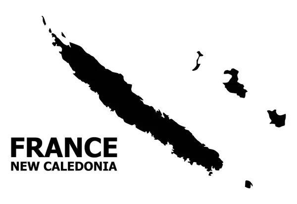
Silhouette Of The State Borders Of Nouvelle-Caledonie. A Special Administrative-territorial Entity Of France Located In The Pacific Ocean. Vector Black And White Illustration.

Vector, 0.35MB, 5716 × 3271 eps
stock vector New Caledonia map icon vector illustration symbol dsign

New Caledonia Map Icon Vector Illustration Symbol Dsign

Vector, 1.04MB, 8333 × 8333 eps
stock vector New Caledonia map with administrative divisions. Vector illustration.

New Caledonia Map With Administrative Divisions. Vector Illustration.

Vector, 6.87MB, 7000 × 3500 eps
stock vector Vermont, U.S. state, subdivided into 14 counties, multi colored political map with capital Montpelier, borders and county names. State in the New England region of United States. Green Mountain State.

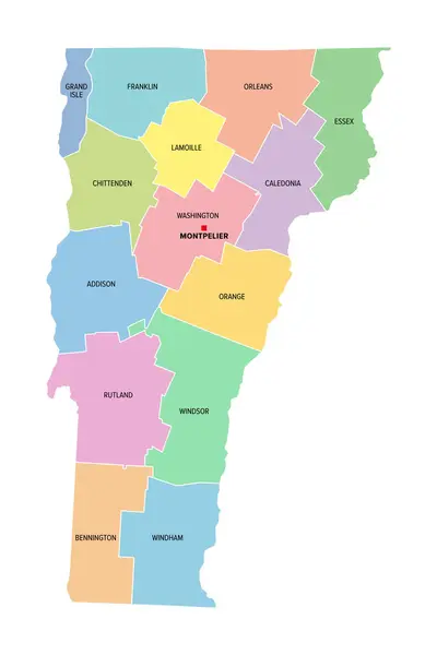
Vermont, U.S. State, Subdivided Into 14 Counties, Multi Colored Political Map With Capital Montpelier, Borders And County Names. State In The New England Region Of United States. Green Mountain State.

Vector, 1.52MB, 6000 × 9000 eps
stock vector New Caledonia map icon vector illustration symbol dsign

New Caledonia Map Icon Vector Illustration Symbol Dsign

Vector, 0.97MB, 8333 × 8333 eps
stock image New Caledonia on the map of Australasia (Oceania) in soft grunge and vintage style, like old paper with watercolor painting.

New Caledonia On The Map Of Australasia (Oceania) In Soft Grunge And Vintage Style, Like Old Paper With Watercolor Painting.

Image, 13.22MB, 7000 × 5000 jpg
Page 3