photo free
Home Images Vectors Videos

Stock image Pangea

stock image Pangaea or Pangea Earth Supercontinent in planet earth rotating

Pangaea Or Pangea Earth Supercontinent In Planet Earth Rotating

Image, 5.18MB, 7585 × 4000 jpg
stock vector Vector graphic of the land mass of the supercontinent Pangea

Vector Graphic Of The Land Mass Of The Supercontinent Pangea

Vector, 0.75MB, 4817 × 3100 eps
stock vector Pangaea

Pangaea

Vector, 1MB, 5000 × 6138 eps
stock vector Planet earth before and after

Planet Earth Before And After

Vector, 1.29MB, 5000 × 3032 eps
stock image The continental drift and the formation of the continents by the separation of Pangaea

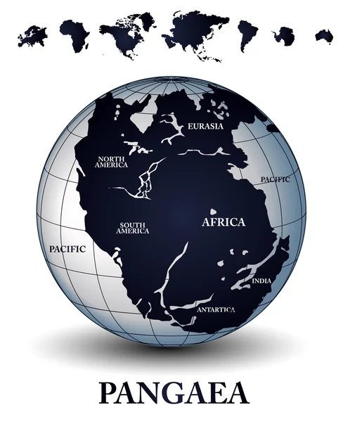
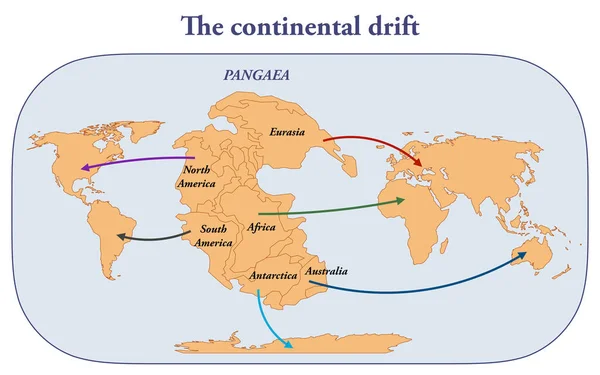
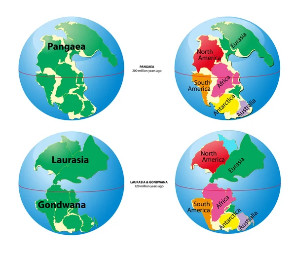
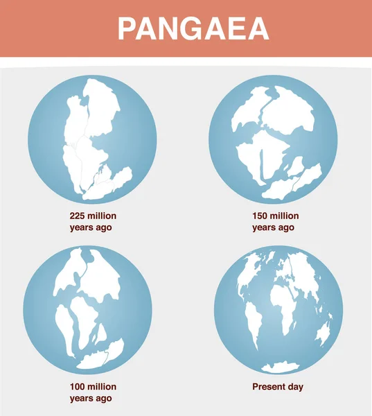
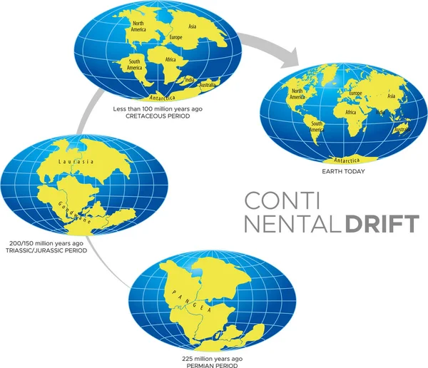
The Continental Drift And The Formation Of The Continents By The Separation Of Pangaea

Image, 1.37MB, 3200 × 2000 jpg
stock image Pangaea continent on earth planet

Pangaea Continent On Earth Planet

Image, 14.68MB, 5000 × 5000 jpg
stock vector Continental drift. Vector illustration of Pangaea, Laurasia, Gondwana, modern continents in flat style. The movement of mainlands on the planet Earth in different periods from 250 MYA to Present.

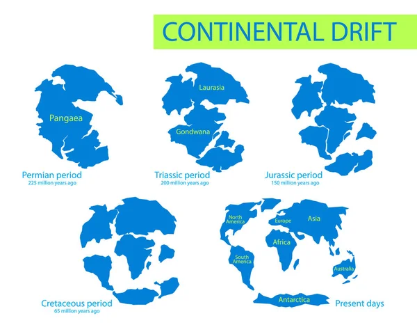
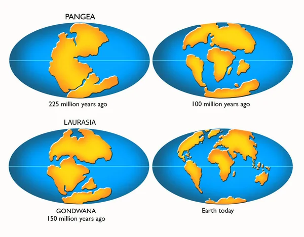
Continental Drift. Vector Illustration Of Pangaea, Laurasia, Gondwana, Modern Continents In Flat Style. The Movement Of Mainlands On The Planet Earth In Different Periods From 250 MYA To Present.

Vector, 1.41MB, 6418 × 5000 eps
stock vector Continental drift. The movement of mainlands on the planet Earth in different periods from 250 MYA to Present. Vector illustration of Pangaea, Laurasia, Gondwana, modern continents in flat style

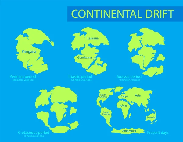
Continental Drift. The Movement Of Mainlands On The Planet Earth In Different Periods From 250 MYA To Present. Vector Illustration Of Pangaea, Laurasia, Gondwana, Modern Continents In Flat Style

Vector, 1.4MB, 6418 × 5000 eps
stock vector Pangaea or Pangea. Vector illustration of supercontinent that existed during the late Paleozoic and early Mesozoic eras. Map of green ancient continent and ocean in flat style. Poster. Education

Pangaea Or Pangea. Vector Illustration Of Supercontinent That Existed During The Late Paleozoic And Early Mesozoic Eras. Map Of Green Ancient Continent And Ocean In Flat Style. Poster. Education

Vector, 4.63MB, 5000 × 6667 eps
stock vector World map of Pangaea, Laurasia, Gondwana and sea Tetis

World Map Of Pangaea, Laurasia, Gondwana And Sea Tetis

Vector, 2.36MB, 4724 × 4072 eps
stock vector Pangaea or Pangea. Vector illustration of supercontinent that existed during the late Paleozoic and early Mesozoic eras. Map in flat style. Element for your design, print, education. Poster.

Pangaea Or Pangea. Vector Illustration Of Supercontinent That Existed During The Late Paleozoic And Early Mesozoic Eras. Map In Flat Style. Element For Your Design, Print, Education. Poster.

Vector, 4.63MB, 5000 × 6667 eps
stock vector Map of Pangaea with modern continental borders. Continental drift on the planet Earth. millions years ago. vector illustration for educational and science use

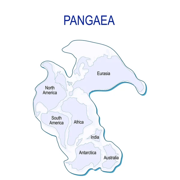
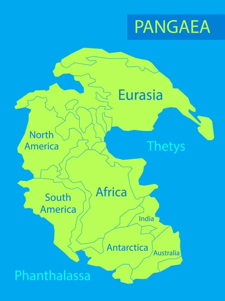
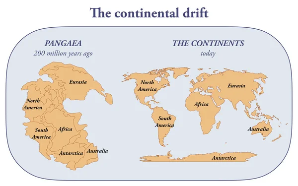
Map Of Pangaea With Modern Continental Borders. Continental Drift On The Planet Earth. Millions Years Ago. Vector Illustration For Educational And Science Use

Vector, 0.48MB, 4228 × 4228 eps
stock image creation of the continents

Creation Of The Continents

Image, 7.87MB, 9449 × 7087 jpg
stock vector Plate tectonics

Plate Tectonics

Vector, 1.35MB, 7064 × 3964 eps
stock image The Old Wife at Five islands, NS

The Old Wife At Five Islands, NS

Image, 11.56MB, 5400 × 3600 jpg
stock image Pangaea continent on earth planet

Pangaea Continent On Earth Planet

Image, 13.5MB, 5000 × 5000 jpg
stock vector Continental drift on the planet Earth

Continental Drift On The Planet Earth

Vector, 2.48MB, 3957 × 4418 eps
stock image VODNJAN, CROATIA - OCTOBER 6, 2020 - The modern campus of the global IT company Infobip with all the accompanying facilities, aerial view, Istria, Croatia

VODNJAN, CROATIA - OCTOBER 6, 2020 - The Modern Campus Of The Global IT Company Infobip With All The Accompanying Facilities, Aerial View, Istria, Croatia

Image, 15.97MB, 5464 × 3640 jpg
stock image VODNJAN, CROATIA - OCTOBER 6, 2020 - The modern campus of the global IT company Infobip with all the accompanying facilities, aerial view

VODNJAN, CROATIA - OCTOBER 6, 2020 - The Modern Campus Of The Global IT Company Infobip With All The Accompanying Facilities, Aerial View

Image, 12.47MB, 5464 × 3640 jpg
stock image Pangea, Laurasia, Gondwana, continental drift, diagram-illustration, isolated image on a white background

Pangea, Laurasia, Gondwana, Continental Drift, Diagram-illustration, Isolated Image On A White Background

Image, 4.49MB, 5750 × 4500 jpg
stock vector Vector illustration of Continental Drift Theory.

Vector Illustration Of Continental Drift Theory.

Vector, 3.24MB, 3000 × 2581 eps
stock vector Monochrome vector illustration silhouettes of Worldmap at Permian, Jurassic, Paleogen and Quartenary periods isolated on background. Continental drift and changes of Earth map.

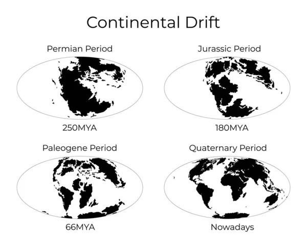
Monochrome Vector Illustration Silhouettes Of Worldmap At Permian, Jurassic, Paleogen And Quartenary Periods Isolated On Background. Continental Drift And Changes Of Earth Map.

Vector, 3.6MB, 6250 × 5000 eps
stock vector Pangaea school globe

Pangaea School Globe

Vector, 1.34MB, 5000 × 5585 eps
stock image VODNJAN, CROATIA - OCTOBER 6, 2020 - The modern campus of the global IT company Infobip with all the accompanying facilities, aerial view

VODNJAN, CROATIA - OCTOBER 6, 2020 - The Modern Campus Of The Global IT Company Infobip With All The Accompanying Facilities, Aerial View

Image, 15.83MB, 5464 × 3640 jpg
stock vector 3D Isometric Flat Vector Conceptual Illustration of Continental Drift, Planet Earth Before and After

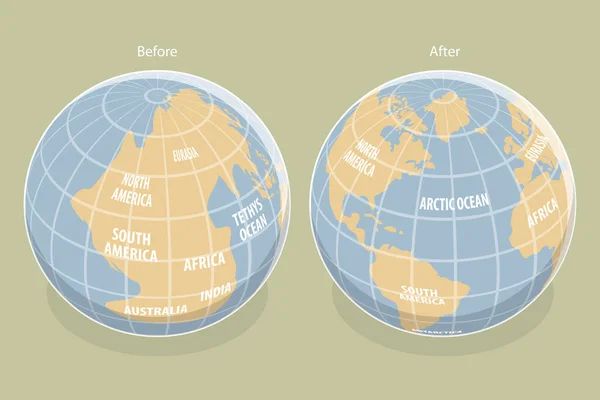
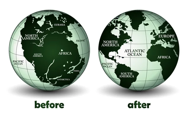
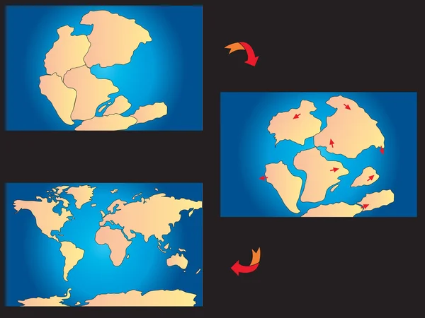
3D Isometric Flat Vector Conceptual Illustration Of Continental Drift, Planet Earth Before And After

Vector, 2.79MB, 6000 × 4000 eps
stock image Pangaea continent on earth planet

Pangaea Continent On Earth Planet

Image, 14.51MB, 5000 × 5000 jpg
stock vector globe with supercontinent Pangaea, modern continental borders, and Superocean Panthalassa. Pangea Maps. Continental drift theory. planet Earth millions years ago. vector illustration for educational, physics, geology, and science use

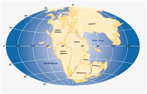
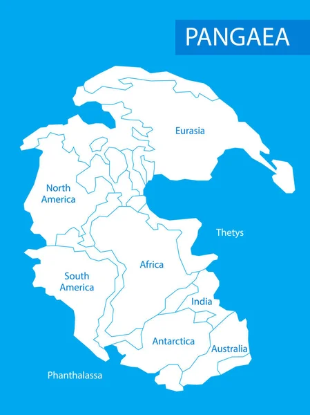
Globe With Supercontinent Pangaea, Modern Continental Borders, And Superocean Panthalassa. Pangea Maps. Continental Drift Theory. Planet Earth Millions Years Ago. Vector Illustration For Educational, Physics, Geology, And Science Use

Vector, 12.04MB, 5000 × 3455 eps
stock vector 3D Isometric Flat Vector Illustration of Paleozoic And Mesozoic Eras, Continental Drift. Item 4

3D Isometric Flat Vector Illustration Of Paleozoic And Mesozoic Eras, Continental Drift. Item 4

Vector, 0.79MB, 5000 × 5000 eps
stock image The continental drift and the evolution of the earth from Pangaea to today

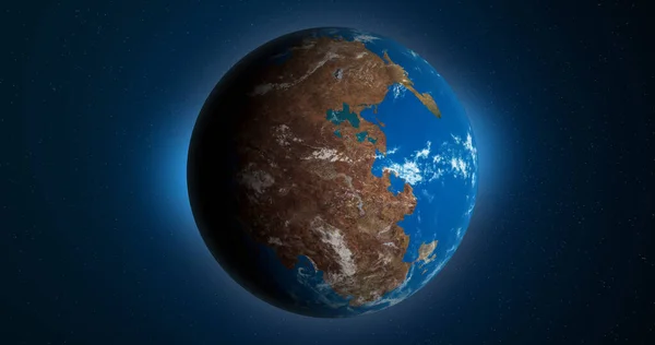
The Continental Drift And The Evolution Of The Earth From Pangaea To Today

Image, 1.49MB, 3200 × 2000 jpg
stock vector Continental drift and changes of Earth map. Colorful vector illustration of Worldmap at Permian, Jurassic, Paleogen and Quartenary periods isolated on background.

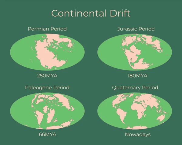
Continental Drift And Changes Of Earth Map. Colorful Vector Illustration Of Worldmap At Permian, Jurassic, Paleogen And Quartenary Periods Isolated On Background.

Vector, 3.62MB, 6250 × 5000 eps
Page 1 >> Next