Home
Images
Vectors
Videos
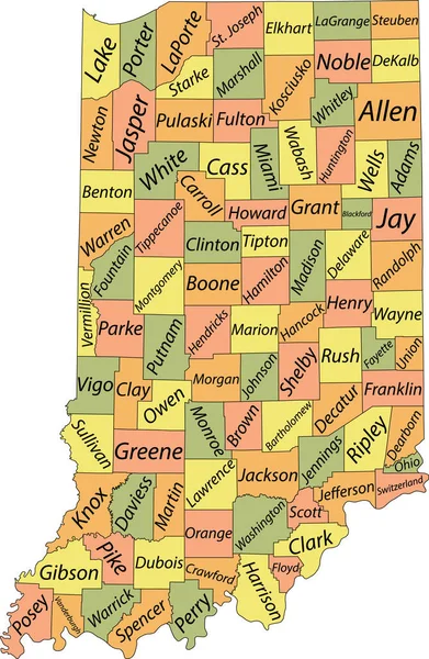
Stock vector Indiana, U.S. state, subdivided into 92 counties, multi colored political map with capital Indianapolis, borders and county names. State in the Midwestern region of United States. The Hoosier State.
Published:
Sep.17, 2024 09:34:16
Author:
Furian
Views:
0
Downloads:
0
File type:
vector
/
eps
File size:
2.03 MB
Orginal size:
6000
x
8826
px
Available sizes:
S
(340 x 500)
M
(680 x 1000)
L
(1360 x 2000)
XL
(6000 x 8826)
VECT
(6000 x 8826)
EL0
(6000 x 8826)
Level:
silver
Download Vector
Vector topics:
Colors
Vector
Illustration
Isolated
Silhouette
Border
Structure
Usa
Capital
In
Country
District
Map
Cartography
Geography
Land
Overview
State
America
Boundary
Administrative
States
Division
Federal
Atlas
Americas
Subdivision
Indiana
County
Midwest
Mapping
Hamilton
Indianapolis
Allen
Marion
Counties
Midwestern
Elkhart
Infographic
Multi Colored
Travel Destination
United States
St Joseph
Subdivided
Tippecanoe
Political Map
Swing State
Hoosier State
Lake County
Similar stock vectors
Pennsylvania, U.S. State, Subdivided Into 67 Counties, Multi Colored Political Map With Capital Harrisburg, And Borders. State Of The Mid-Atlantic And Northeastern USA, With Nickname Keystone State.
9000 × 5625
Colorful Indiana Political Map With Clearly Labeled, Separated Layers. Vector Illustration.
3392 × 4765
Pastel Vector Map Of The Federal State Of Indiana, USA With Black Borders And Names Of Its Counties
3986 × 6105
Pennsylvania Administrative And Political Vector Map
4394 × 3100
Pennsylvania Map
7002 × 7002
Accurate Map Of Indiana
4000 × 5000
Ohio Counties, Gray Political Map With Borders And County Names. State In The Midwestern Region Of The United States, Subdivided Into 88 Counties. Nicknamed Buckeye State, And Heart Of It All.
6000 × 6525
Colorful County Map With Counties Names Of The US Federal State Of Pennsylvania
4800 × 3600