photo free
Home Images Vectors Videos

Stock image Amsterdam Islands

stock image Amsterdam canal with houseboats

Amsterdam Canal With Houseboats

Image, 9.5MB, 4288 × 2848 jpg
stock image Willemstad, Curacao, ABC Islands

Willemstad, Curacao, ABC Islands

Image, 18.57MB, 25450 × 3048 jpg
stock image Modern architecture houses in a canal in Amsterdam

Modern Architecture Houses In A Canal In Amsterdam

Image, 7.71MB, 6016 × 4016 jpg
stock image houses at the waterfront

Houses At The Waterfront

Image, 9.16MB, 4465 × 3919 jpg
stock image houses at the waterfront

Houses At The Waterfront

Image, 7.09MB, 4866 × 3159 jpg
stock image houses at the waterfront

Houses At The Waterfront

Image, 9.1MB, 4811 × 3186 jpg
stock vector Netherlands Political Map

Netherlands Political Map

Vector, 3.76MB, 6000 × 6868 eps
stock vector the Netherlands and provinces

The Netherlands And Provinces

Vector, 1.38MB, 5079 × 5079 eps
stock image View of Smeerenburg bay and glaciers in Spitsbergen islands, Svalbard, Norway.

View Of Smeerenburg Bay And Glaciers In Spitsbergen Islands, Svalbard, Norway.

Image, 14.24MB, 9000 × 6000 jpg
stock vector Belgium, the netherlands, luxembourg

Belgium, The Netherlands, Luxembourg

Vector, 1.84MB, 5079 × 5079 eps
stock image Street landscape of the city Road Town in Tortola in the Caribbean Sea

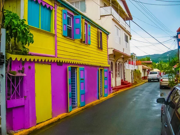
Street Landscape Of The City Road Town In Tortola In The Caribbean Sea

Image, 3.56MB, 3100 × 2325 jpg
stock vector Highly detailed vector map of Netherlands with administrative regions,main cities and roads.

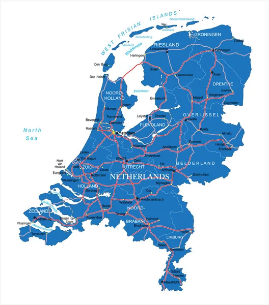
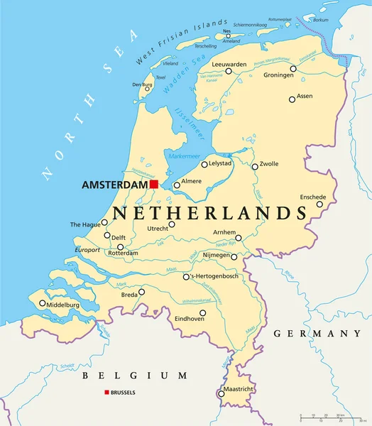
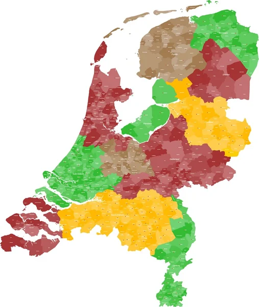
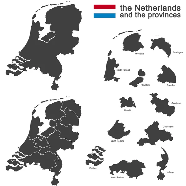
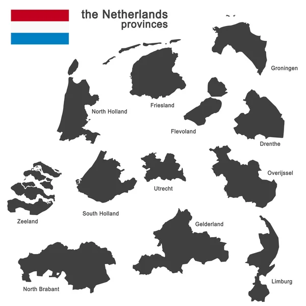
Highly Detailed Vector Map Of Netherlands With Administrative Regions,main Cities And Roads.

Vector, 0.84MB, 6571 × 7463 ai
stock vector Netherlands political map gray colored

Netherlands Political Map Gray Colored

Vector, 2.69MB, 7275 × 8333 eps
stock vector Saint Martin Island Political Map

Saint Martin Island Political Map

Vector, 1.03MB, 8445 × 6000 eps
stock image Dunes at the Marker Wadden, manmade Dutch archipelago.

Dunes At The Marker Wadden, Manmade Dutch Archipelago.

Image, 16.07MB, 6639 × 4427 jpg
stock vector Sint Maarten Political Map

Sint Maarten Political Map

Vector, 0.95MB, 7790 × 6000 eps
stock vector Map of the Netherlands

Map Of The Netherlands

Vector, 3.25MB, 4230 × 5000 ai
stock vector the Netherlands and provinces

The Netherlands And Provinces

Vector, 0.52MB, 5054 × 5669 eps
stock vector Belgium, the netherlands, luxembourg

Belgium, The Netherlands, Luxembourg

Vector, 0.69MB, 4724 × 5906 eps
stock image indonesian people working in harbor

Indonesian People Working In Harbor

Image, 1.25MB, 2600 × 1730 jpg
stock vector country the Netherlands

Country The Netherlands

Vector, 1.1MB, 5079 × 5079 eps
stock vector country the Netherlands

Country The Netherlands

Vector, 0.88MB, 5079 × 5079 eps
stock image Row modern architecture houses in Amsterdam

Row Modern Architecture Houses In Amsterdam

Image, 5.22MB, 5409 × 3611 jpg
stock vector the Netherlands and provinces

The Netherlands And Provinces

Vector, 4.08MB, 5079 × 5079 eps
stock vector BeNeLux countries

BeNeLux Countries

Vector, 1.2MB, 4724 × 6240 eps
stock vector country the Netherlands

Country The Netherlands

Vector, 0.75MB, 5079 × 5079 eps
stock vector Flag of Netherlands from brush strokes and Blank map of Netherlands. High quality map Netherlands and national flag on transparent background for your web site design. Europe. EPS10.

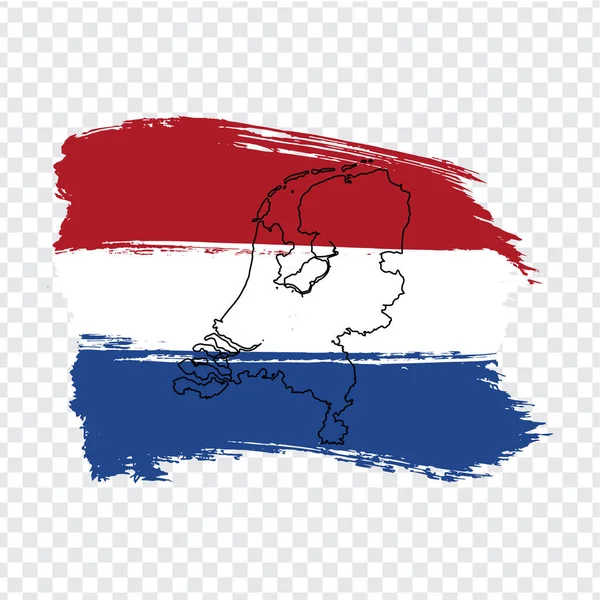
Flag Of Netherlands From Brush Strokes And Blank Map Of Netherlands. High Quality Map Netherlands And National Flag On Transparent Background For Your Web Site Design. Europe. EPS10.

Vector, 3.9MB, 5000 × 5000 eps
stock vector Belgium, the netherlands, luxembourg

Belgium, The Netherlands, Luxembourg

Vector, 7.73MB, 5079 × 5079 eps
stock vector country the Netherlands

Country The Netherlands

Vector, 0.88MB, 5079 × 5079 eps
stock image Flag of Saba

Flag Of Saba

Image, 1.44MB, 3072 × 1920 jpg
stock image indonesian people working in harbor

Indonesian People Working In Harbor

Image, 1.04MB, 2600 × 1730 jpg
stock vector High quality colorful labeled map of Netherlands with borders of the provinces

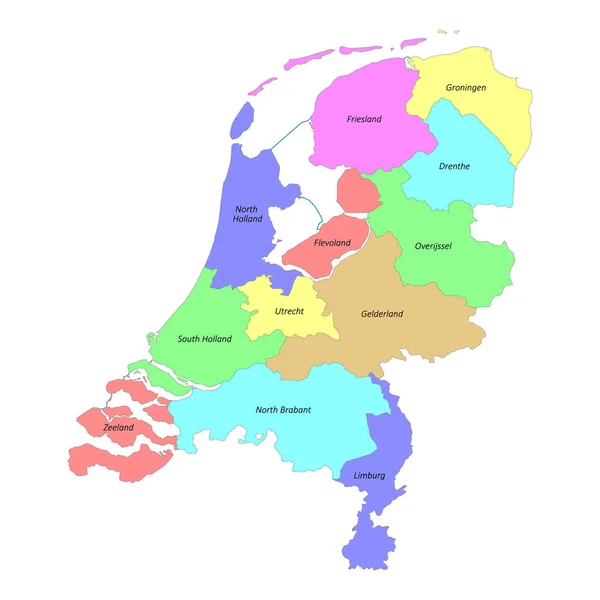
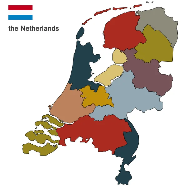
High Quality Colorful Labeled Map Of Netherlands With Borders Of The Provinces

Vector, 1.58MB, 4000 × 4000 eps
stock vector all Flags of regions of Nerherlands. Vector illustraion

All Flags Of Regions Of Nerherlands. Vector Illustraion

Vector, 5.62MB, 6765 × 4000 eps
stock vector all flags of the Netherlands regions

All Flags Of The Netherlands Regions

Vector, 6.2MB, 5505 × 4000 eps
stock vector BeNeLux countries

BeNeLux Countries

Vector, 1.51MB, 5079 × 5079 eps
stock vector BeNeLux countries

BeNeLux Countries

Vector, 1.2MB, 4724 × 6240 eps
stock vector Benelux countries, gray colored political map. Belgium, Netherlands and Luxembourg. Benelux Union, a geographic, economic and cultural group. English labeling. Illustration on white background. Vector

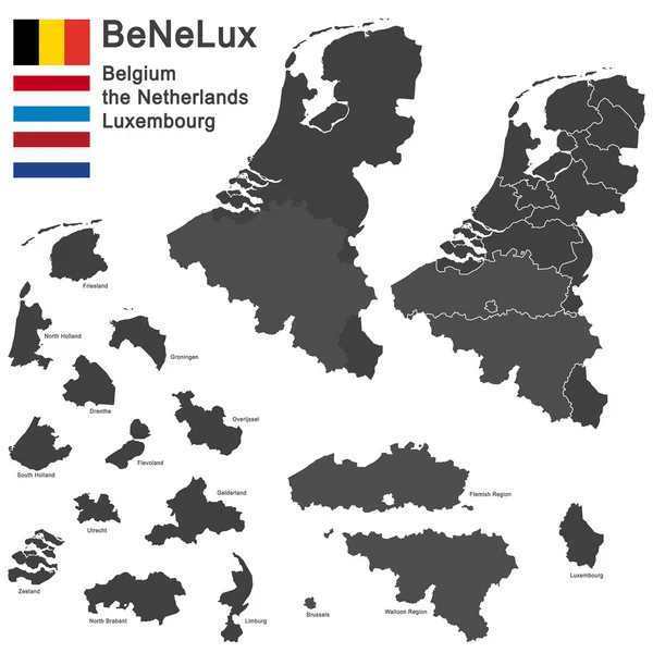
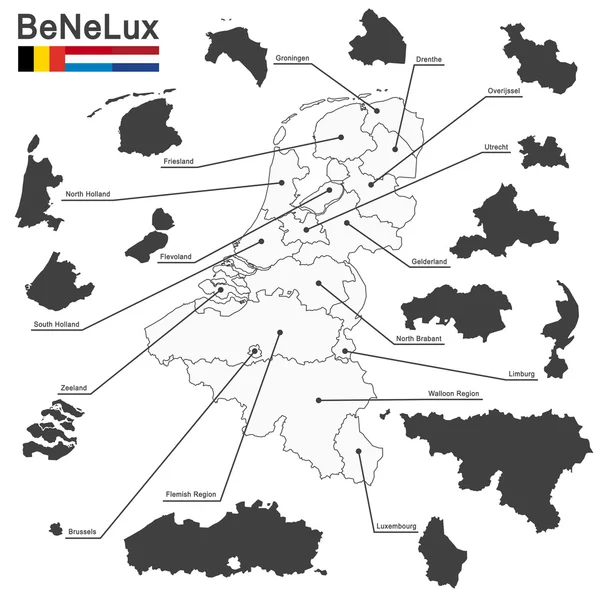
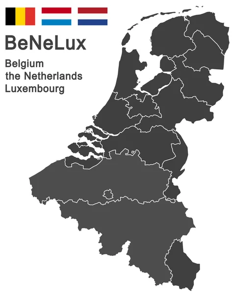
Benelux Countries, Gray Colored Political Map. Belgium, Netherlands And Luxembourg. Benelux Union, A Geographic, Economic And Cultural Group. English Labeling. Illustration On White Background. Vector

Vector, 3.21MB, 6867 × 9333 eps
stock vector colored silhouettes of the netherlands, Luxembourg and Belgium

Colored Silhouettes Of The Netherlands, Luxembourg And Belgium

Vector, 1.24MB, 7467 × 9862 eps
stock vector Cannabis

Cannabis

Vector, 0.64MB, 7746 × 4904 ai
stock vector Flag of Netherlands

Flag Of Netherlands

Vector, 5.4MB, 8000 × 5340 eps
stock image Tortola, British Vigin Islands - 30th January 2024:New Amsterdam sailing out of BVI

Tortola, British Vigin Islands - 30th January 2024:New Amsterdam Sailing Out Of BVI

Image, 6.17MB, 4231 × 2113 jpg
stock image Tortola, British Vigin Islands - 30th January 2024:New Amsterdam carrying out liftboat drill

Tortola, British Vigin Islands - 30th January 2024:New Amsterdam Carrying Out Liftboat Drill

Image, 16.51MB, 5434 × 3634 jpg
stock image Tortola, British Vigin Islands - 30th January 2024:Enchanted Princess alongside in BVI

Tortola, British Vigin Islands - 30th January 2024:Enchanted Princess Alongside In BVI

Image, 24.8MB, 7169 × 4785 jpg
stock vector Political map of Netherlands with national borders, cities and rivers

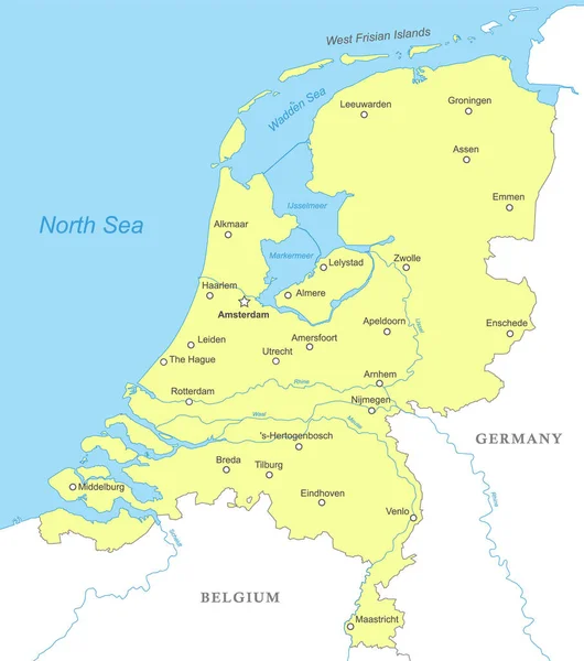
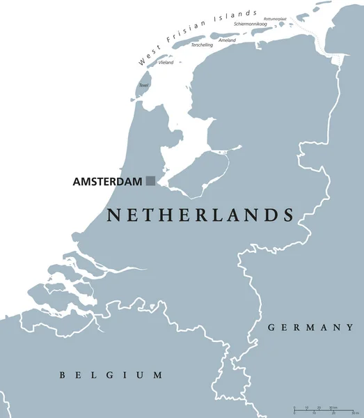
Political Map Of Netherlands With National Borders, Cities And Rivers

Vector, 1.55MB, 4000 × 4520 eps
stock image Tortola, British Vigin Islands - 30th January 2024:New Amsterdam carrying out liftboat drill

Tortola, British Vigin Islands - 30th January 2024:New Amsterdam Carrying Out Liftboat Drill

Image, 6.03MB, 3194 × 2123 jpg
stock image Tortola, British Vigin Islands - 30th January 2024:New Amsterdam alongside in the BVI

Tortola, British Vigin Islands - 30th January 2024:New Amsterdam Alongside In The BVI

Image, 27.8MB, 4912 × 7360 jpg
stock image Tortola, British Vigin Islands - 30th January 2024:New Amsterdam sailing out of BVI

Tortola, British Vigin Islands - 30th January 2024:New Amsterdam Sailing Out Of BVI

Image, 7.34MB, 4103 × 2729 jpg
stock image Tortola, British Vigin Islands - 30th January 2024:New Amsterdam alongside in the BVI

Tortola, British Vigin Islands - 30th January 2024:New Amsterdam Alongside In The BVI

Image, 19.5MB, 6698 × 4470 jpg
stock image Tortola, British Vigin Islands - 30th January 2024:New Amsterdam carrying out liftboat drill

Tortola, British Vigin Islands - 30th January 2024:New Amsterdam Carrying Out Liftboat Drill

Image, 8.85MB, 4135 × 2751 jpg
stock image Tortola, British Vigin Islands - 30th January 2024:New Amsterdam sailing out of BVI

Tortola, British Vigin Islands - 30th January 2024:New Amsterdam Sailing Out Of BVI

Image, 13.27MB, 6407 × 3631 jpg
Page 1 >> Next