photo free
Home Images Vectors Videos

Stock image English Labeling

stock vector Guernsey and Jersey, Channel Islands, political map

Guernsey And Jersey, Channel Islands, Political Map

Vector, 2.81MB, 6555 × 9833 eps
stock vector Cook Islands political map with capital Avarua. Self-governing island country in South Pacific Ocean in free association with New Zealand, comprising 15 islands. English labeling. Illustration. Vector

Cook Islands Political Map With Capital Avarua. Self-governing Island Country In South Pacific Ocean In Free Association With New Zealand, Comprising 15 Islands. English Labeling. Illustration. Vector

Vector, 1.66MB, 6000 × 6000 eps
stock vector Guernsey and Jersey, Channel Islands, gray political map

Guernsey And Jersey, Channel Islands, Gray Political Map

Vector, 2.67MB, 6489 × 9733 eps
stock vector Sizes of major religious groups. World religions. Bar chart

Sizes Of Major Religious Groups. World Religions. Bar Chart

Vector, 2.59MB, 7557 × 8566 eps
stock vector Mascarene Islands political map, Mauritius, Reunion and Rodrigues

Mascarene Islands Political Map, Mauritius, Reunion And Rodrigues

Vector, 2.69MB, 10666 × 5913 eps
stock vector Maldives political map

Maldives Political Map

Vector, 2.41MB, 6444 × 9666 eps
stock vector Channel Islands Guernsey and Jersey, political map

Channel Islands Guernsey And Jersey, Political Map

Vector, 2.89MB, 6555 × 9833 eps
stock vector Isle of Man political map

Isle Of Man Political Map

Vector, 3.14MB, 8033 × 8033 eps
stock vector North Macedonia political map with capital Skopje, borders, important cities, rivers and lakes. Former Yugoslav Republic of Macedonia, renamed in February 2019. English labeling. Illustration. Vector.

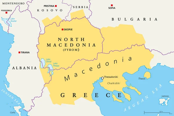
North Macedonia Political Map With Capital Skopje, Borders, Important Cities, Rivers And Lakes. Former Yugoslav Republic Of Macedonia, Renamed In February 2019. English Labeling. Illustration. Vector.

Vector, 3.2MB, 8933 × 7181 eps
stock vector Central Africa region, political map

Central Africa Region, Political Map

Vector, 3.84MB, 6489 × 9733 eps
stock vector Map of Africa with separated countries.

Map Of Africa With Separated Countries.

Vector, 7.18MB, 6001 × 4265 eps
stock vector Hong Kong detailed editable map

Hong Kong Detailed Editable Map

Vector, 0.33MB, 5010 × 6000 eps
stock vector Channel Islands Guernsey and Jersey, gray political map

Channel Islands Guernsey And Jersey, Gray Political Map

Vector, 2.73MB, 6489 × 9733 eps
stock vector New Mexico United States political map

New Mexico United States Political Map

Vector, 3.38MB, 7674 × 8333 eps
stock vector Korean Peninsula, Demilitarized Zone Area, political map. North and South Korea with red Military Demarcation Line, capitals and borders. English labeling. Gray illustration, white background. Vector.

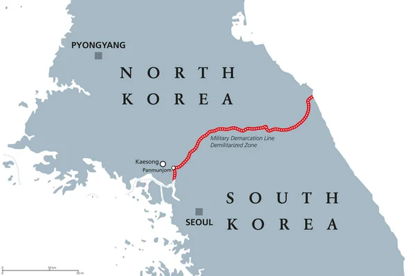
Korean Peninsula, Demilitarized Zone Area, Political Map. North And South Korea With Red Military Demarcation Line, Capitals And Borders. English Labeling. Gray Illustration, White Background. Vector.

Vector, 2.74MB, 9666 × 6444 eps
stock vector Megacities of the world, political map. Largest cities with more than ten million people. Metropolitan areas Tokyo, Shanghai and Jakarta with most inhabitants. English labeling. Illustration. Vector.

Megacities Of The World, Political Map. Largest Cities With More Than Ten Million People. Metropolitan Areas Tokyo, Shanghai And Jakarta With Most Inhabitants. English Labeling. Illustration. Vector.

Vector, 5.41MB, 11033 × 5658 eps
stock vector Sao Tome and Principe Political Map

Sao Tome And Principe Political Map

Vector, 0.62MB, 5761 × 9000 eps
stock vector Periodic Table of the elements ENGLISH

Periodic Table Of The Elements ENGLISH

Vector, 3.32MB, 8386 × 6000 eps
stock vector Sao Miguel Island, Azores, Portugal, political map, with capital Ponta Delgada. Nicknamed The Green Island, the largest and most populous island in the Portuguese archipelago of the Azores. Vector.

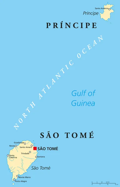
Sao Miguel Island, Azores, Portugal, Political Map, With Capital Ponta Delgada. Nicknamed The Green Island, The Largest And Most Populous Island In The Portuguese Archipelago Of The Azores. Vector.

Vector, 1.81MB, 9000 × 6000 eps
stock vector Macaronesia, gray map, Azores, Cape Verde, Madeira, Canary Islands

Macaronesia, Gray Map, Azores, Cape Verde, Madeira, Canary Islands

Vector, 3.09MB, 6670 × 9466 eps
stock vector Size of major religiuos groups pie chart with percentages

Size Of Major Religiuos Groups Pie Chart With Percentages

Vector, 2.09MB, 8833 × 7288 eps
stock vector East Africa region, political map

East Africa Region, Political Map

Vector, 4.15MB, 6490 × 9733 eps
stock vector Crete, Greek island, political map, with capital Heraklion. Largest island of Greece and fifth largest in the Mediterranean Sea. With the major Minoan settlements Knossos, Phaistos, Malia and Zakros.

Crete, Greek Island, Political Map, With Capital Heraklion. Largest Island Of Greece And Fifth Largest In The Mediterranean Sea. With The Major Minoan Settlements Knossos, Phaistos, Malia And Zakros.

Vector, 2.68MB, 9000 × 5089 eps
stock vector Arctic Region Map and Flat Map Icons

Arctic Region Map And Flat Map Icons

Vector, 4.89MB, 6410 × 8192 eps
stock vector Singapore political map

Singapore Political Map

Vector, 2.64MB, 9133 × 6986 eps
stock vector Colorful hand drawn political map of Africa.

Colorful Hand Drawn Political Map Of Africa.

Vector, 9.25MB, 6001 × 6001 eps
stock vector Golan Heights political map

Golan Heights Political Map

Vector, 3.58MB, 6497 × 9733 eps
stock vector Colorful hand drawn political map of Africa.

Colorful Hand Drawn Political Map Of Africa.

Vector, 6.98MB, 6001 × 5713 eps
stock vector Lanzarote, political map, with capital Arrecife. Northernmost and easternmost island of Canary Islands, an archipelago and autonomous community of Spain, in the Atlantic Ocean off the coast of Africa.

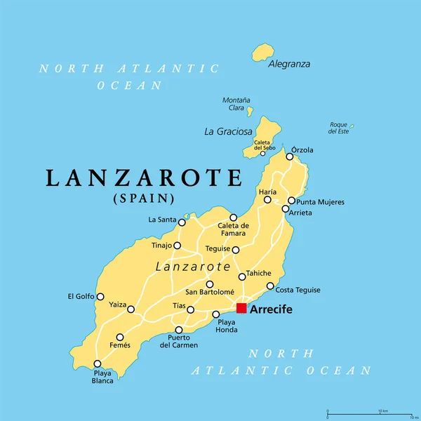
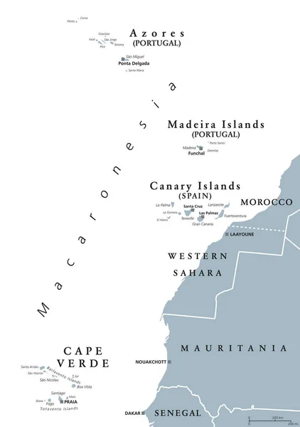
Lanzarote, Political Map, With Capital Arrecife. Northernmost And Easternmost Island Of Canary Islands, An Archipelago And Autonomous Community Of Spain, In The Atlantic Ocean Off The Coast Of Africa.

Vector, 2.31MB, 6000 × 6000 eps
stock vector Oahu, Hawaii, political map with capital Honolulu. Part of the Hawaiian Islands and Hawaii, a state of the United States in the North Pacific Ocean. Known as The Gathering Place. Illustration. Vector.

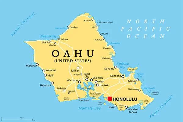
Oahu, Hawaii, Political Map With Capital Honolulu. Part Of The Hawaiian Islands And Hawaii, A State Of The United States In The North Pacific Ocean. Known As The Gathering Place. Illustration. Vector.

Vector, 2.54MB, 9000 × 6000 eps
stock vector French Guiana political map

French Guiana Political Map

Vector, 2.38MB, 7204 × 8888 eps
stock vector Tenerife island, political map, with capital Santa Cruz de Tenerife. Largest and most populous island of Canary Islands, an archipelago and autonomous community of Spain, in the North Atlantic Ocean.

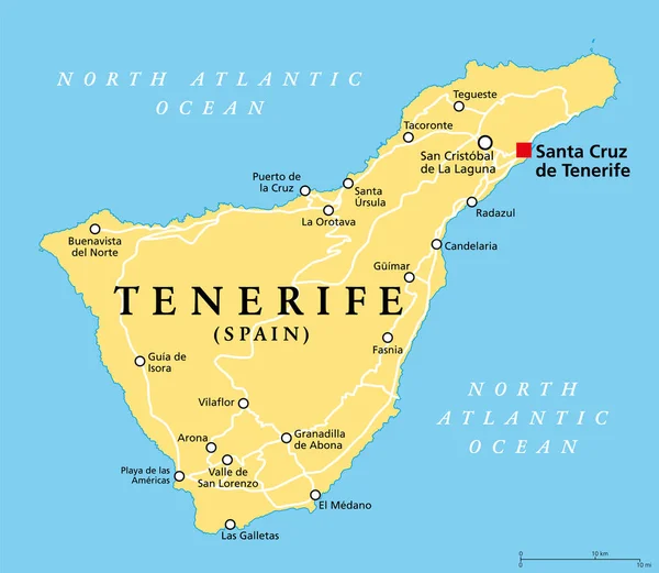
Tenerife Island, Political Map, With Capital Santa Cruz De Tenerife. Largest And Most Populous Island Of Canary Islands, An Archipelago And Autonomous Community Of Spain, In The North Atlantic Ocean.

Vector, 2.24MB, 6901 × 6000 eps
stock vector California political map with capital Sacramento, important cities, rivers, lakes. State in the Pacific Region of the United States. Los Angeles, San Francisco. English labeling. Illustration. Vector.

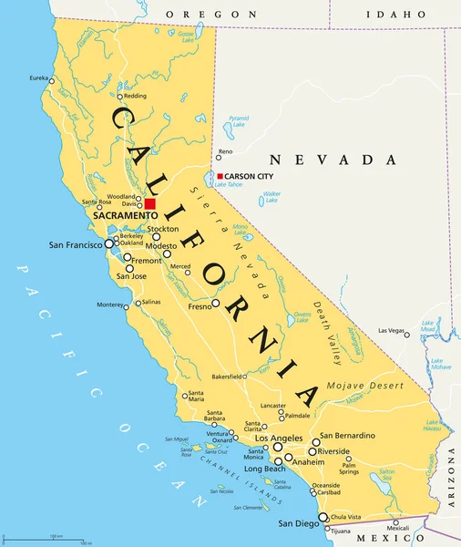
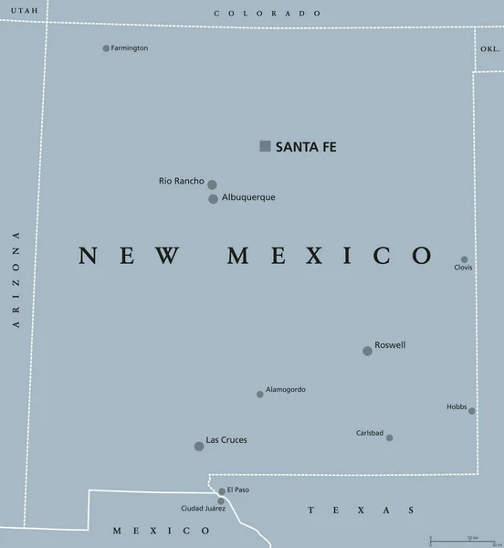
California Political Map With Capital Sacramento, Important Cities, Rivers, Lakes. State In The Pacific Region Of The United States. Los Angeles, San Francisco. English Labeling. Illustration. Vector.

Vector, 3.1MB, 7288 × 8633 eps
stock vector Gaza Strip political map

Gaza Strip Political Map

Vector, 3.1MB, 7198 × 8833 eps
stock image Texas isolated map

Texas Isolated Map

Image, 0.72MB, 5000 × 5000 jpg
stock vector Arab League political map. League of Arab States, location in North Africa and Arabia. Regional organization of 22 member states. Syria is suspended since 2011. English labeling. Illustration. Vector.

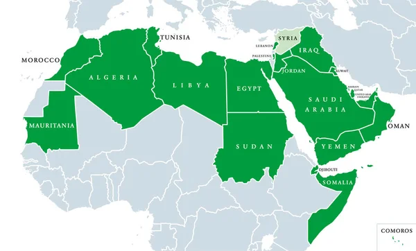
Arab League Political Map. League Of Arab States, Location In North Africa And Arabia. Regional Organization Of 22 Member States. Syria Is Suspended Since 2011. English Labeling. Illustration. Vector.

Vector, 2.42MB, 10333 × 6237 eps
stock vector Southeast Asia political map

Southeast Asia Political Map

Vector, 4.43MB, 7486 × 8555 eps
stock vector Five continents world, political map. Africa, America, Antarctica, Australia and Eurasia, with shorelines and borders. Robinson projection. English labeling. Isolated on white background. Vector.

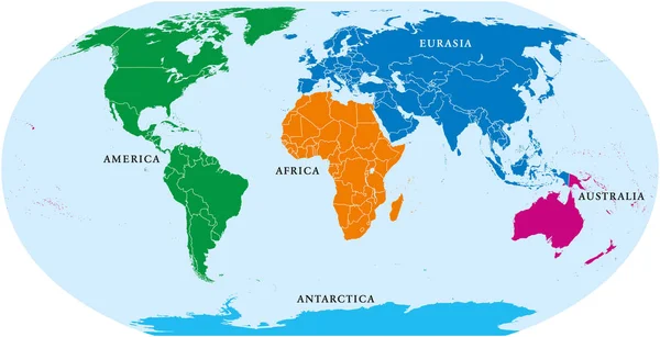
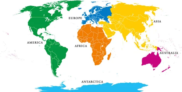
Five Continents World, Political Map. Africa, America, Antarctica, Australia And Eurasia, With Shorelines And Borders. Robinson Projection. English Labeling. Isolated On White Background. Vector.

Vector, 6.68MB, 9933 × 5099 eps
stock vector Peoples Republic of China, PRC, political map. Area controlled by China in yellow, and claimed but uncontrolled regions shown in orange. Capitals and borders. English labeling. Illustration. Vector.

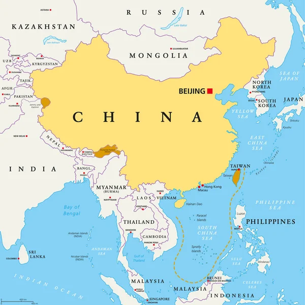
Peoples Republic Of China, PRC, Political Map. Area Controlled By China In Yellow, And Claimed But Uncontrolled Regions Shown In Orange. Capitals And Borders. English Labeling. Illustration. Vector.

Vector, 5.31MB, 8033 × 8033 eps
stock vector Samoan Islands political map

Samoan Islands Political Map

Vector, 1.68MB, 9999 × 5155 eps
stock vector West Africa region, political map

West Africa Region, Political Map

Vector, 3.66MB, 9733 × 6489 eps
stock vector Benelux. Belgium, Netherlands and Luxembourg. Political map with capitals, borders and important cities. Benelux Union, a geographic, economic, cultural group. English labeling. Illustration. Vector.

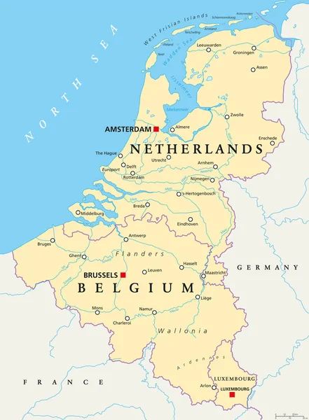
Benelux. Belgium, Netherlands And Luxembourg. Political Map With Capitals, Borders And Important Cities. Benelux Union, A Geographic, Economic, Cultural Group. English Labeling. Illustration. Vector.

Vector, 6.09MB, 6867 × 9333 eps
stock vector Colorful hand drawn political map of Africa with five regions

Colorful Hand Drawn Political Map Of Africa With Five Regions

Vector, 9.21MB, 6001 × 6001 eps
stock vector Patagonia and Falkland Islands political map

Patagonia And Falkland Islands Political Map

Vector, 2.02MB, 7231 × 8833 eps
stock vector Solomon islands map. Flat simple image of archipelago. Vector illustration

Solomon Islands Map. Flat Simple Image Of Archipelago. Vector Illustration

Vector, 0.41MB, 5001 × 4001 eps
stock vector Democratic Republic of the Congo political map

Democratic Republic Of The Congo Political Map

Vector, 3MB, 8333 × 7573 eps
stock vector Six continents, political world map, with borders. Africa, America, Antarctica, Asia, Australia and Europe. Robinson projection. English labeling. Isolated illustration on white background. Vector.

Six Continents, Political World Map, With Borders. Africa, America, Antarctica, Asia, Australia And Europe. Robinson Projection. English Labeling. Isolated Illustration On White Background. Vector.

Vector, 6.66MB, 10633 × 5394 eps
stock vector Regions of Africa political map

Regions Of Africa Political Map

Vector, 4.37MB, 8133 × 7771 eps
stock vector Macedonia region, political map. Region of the Balkan Peninsula in Southeast Europe. Part of Greece, North Macedonia, Bulgaria, Albania, Kosovo and Serbia. English labeling. Illustration. Vector.

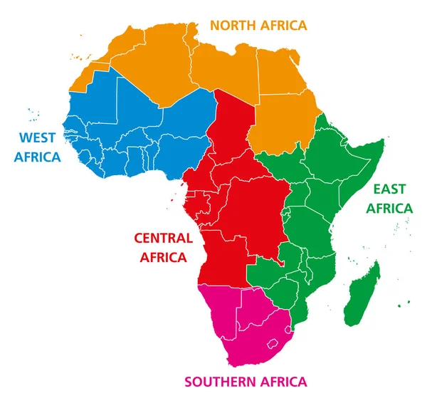
Macedonia Region, Political Map. Region Of The Balkan Peninsula In Southeast Europe. Part Of Greece, North Macedonia, Bulgaria, Albania, Kosovo And Serbia. English Labeling. Illustration. Vector.

Vector, 2.72MB, 9833 × 6555 eps
stock vector Gaza Strip political map. Self governing Palestinian territory on coast of Mediterranean Sea. Borders to Israel and Egypt. Claimed by State of Palestine. English labeling. Gray illustration. Vector.

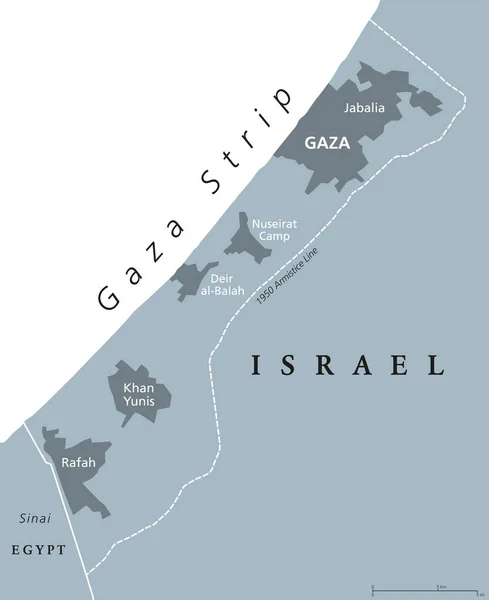
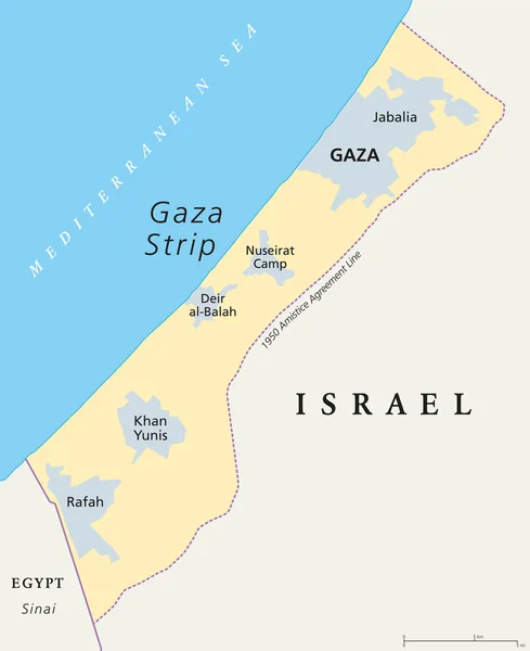
Gaza Strip Political Map. Self Governing Palestinian Territory On Coast Of Mediterranean Sea. Borders To Israel And Egypt. Claimed By State Of Palestine. English Labeling. Gray Illustration. Vector.

Vector, 3.04MB, 7199 × 8833 eps
Page 1 >> Next