Home
Images
Vectors
Videos
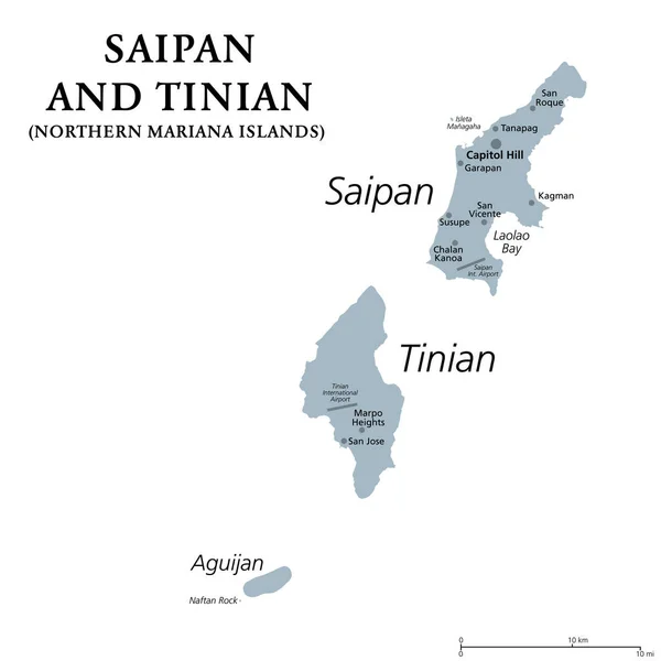
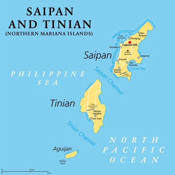
Stock vector Saipan and Tinian, Northern Mariana Islands, political map. Islands of the Mariana Archipelago. Unincorporated territory and commonwealth of the United States, with administrative center Capitol Hill.
Published:
Jun.14, 2023 10:06:01
Author:
Furian
Views:
29
Downloads:
0
File type:
vector
/
eps
File size:
1.84 MB
Orginal size:
6000
x
6000
px
Available sizes:
S
(500 x 500)
M
(1000 x 1000)
L
(2000 x 2000)
XL
(6000 x 6000)
VECT
(6000 x 6000)
EL0
(6000 x 6000)
Level:
silver
Download Vector
Vector topics:
Vector
Illustration
Us
Usa
Capital
Northern
Map
Cartography
Geography
Area
Pacific
Channel
Island
United
Commonwealth
States
Islands
Territory
Atlas
Insular
Micronesia
Mariana
Archipelago
United States
CNMI
San Jose
Unincorporated
Saipan
North Pacific
San Vicente
San Roque
Coral Reef
Capitol Hill
Northern Mariana Islands
Political Map
Unincorporated Territory
Mariana Islands
Philippine Sea
Garapan
Tinian
Kagman
Chalan Kanoa
Tinian Channel
Susupe
Laolao Bay
Mount Tapochau
Saipan Channel
Tanapag
Aguijan
Similar stock vectors
Saipan And Tinian, Northern Mariana Islands, Gray Political Map. Islands Of The Mariana Archipelago. Unincorporated Territory And Commonwealth Of United States With Administrative Center Capitol Hill.
6000 × 6000
Northern Mariana Islands Map
5523 × 6803
East Timor Political Map
7292 × 6000
Northern Mariana Islands Political Map
6974 × 8999
Vector Map Of The Indian Archipelago Of The Andaman Islands
3100 × 4446
Vector Map Of The Indian Archipelago Of The Andaman Islands
3100 × 4446
Papua New Guinea Political Map
9777 × 6518
Samoa Political Map
7629 × 6000