photo free
Home Images Vectors Videos

Stock image District Boundaries

stock vector Gerrymander word cloud on a white background.

Gerrymander Word Cloud On A White Background.

Vector, 13.45MB, 7633 × 5000 eps
stock vector Cheating with Gerrymandering word cloud on a white background.

Cheating With Gerrymandering Word Cloud On A White Background.

Vector, 13.58MB, 7627 × 5000 eps
stock vector Gerrymandering word cloud on a white background.

Gerrymandering Word Cloud On A White Background.

Vector, 5.2MB, 11000 × 5000 eps
stock vector Gerrymandering word cloud on a white background.

Gerrymandering Word Cloud On A White Background.

Vector, 5.22MB, 4077 × 5000 eps
stock vector Gerrymandering word cloud on a white background.

Gerrymandering Word Cloud On A White Background.

Vector, 13.45MB, 6569 × 5000 eps
stock vector Map Redrawing in gerrymandering word cloud on a white background.

Map Redrawing In Gerrymandering Word Cloud On A White Background.

Vector, 0.76MB, 8588 × 5000 eps
stock image Welcome to Lambeth

Welcome To Lambeth

Image, 13.08MB, 5112 × 3502 jpg
stock image On the Road to Edale

On The Road To Edale

Image, 4.03MB, 4752 × 3168 jpg
stock image Satellite view of the city of Milan, map and streets. Lombardy, Italy. Boundaries. Expo. Fair. 3d render

Satellite View Of The City Of Milan, Map And Streets. Lombardy, Italy. Boundaries. Expo. Fair. 3d Render

Image, 24.47MB, 5511 × 5511 jpg
stock vector Finland provinces maps

Finland Provinces Maps

Vector, 5.09MB, 6000 × 4636 eps
stock vector Albania provinces maps

Albania Provinces Maps

Vector, 4.28MB, 6000 × 4636 eps
stock vector Northern ireland provinces maps

Northern Ireland Provinces Maps

Vector, 8.75MB, 6000 × 4631 eps
stock vector Kosovo provinces maps

Kosovo Provinces Maps

Vector, 13.25MB, 6000 × 4636 eps
stock vector Croatia provinces maps

Croatia Provinces Maps

Vector, 7.11MB, 6000 × 4636 eps
stock vector Italy map

Italy Map

Vector, 0.63MB, 3679 × 5000 ai
stock vector Ukraine provinces maps

Ukraine Provinces Maps

Vector, 7.64MB, 6000 × 4636 eps
stock vector Argentina provinces maps

Argentina Provinces Maps

Vector, 4.14MB, 6000 × 4636 eps
stock vector Cyprus provinces maps

Cyprus Provinces Maps

Vector, 1.06MB, 6000 × 4648 eps
stock vector Bosnia herzegovina provinces maps

Bosnia Herzegovina Provinces Maps

Vector, 2.41MB, 6000 × 4636 eps
stock vector Bolivia provinces maps

Bolivia Provinces Maps

Vector, 1.46MB, 6000 × 4636 eps
stock vector Czech republic provinces maps

Czech Republic Provinces Maps

Vector, 3.69MB, 6000 × 4636 eps
stock vector Portugal provinces maps

Portugal Provinces Maps

Vector, 7.44MB, 5000 × 3864 eps
stock vector Detailed map of the Free State of Thuringia (Germany) with borders of municipalities, municipalities associations, districts, and state. Vector illustration

Detailed Map Of The Free State Of Thuringia (Germany) With Borders Of Municipalities, Municipalities Associations, Districts, And State. Vector Illustration

Vector, 11.38MB, 5000 × 5000 eps
stock vector Netherlands provinces maps

Netherlands Provinces Maps

Vector, 5.62MB, 6000 × 4636 eps
stock image Global Studies - Focus on the City of Washington

Global Studies - Focus On The City Of Washington

Image, 3.62MB, 3264 × 2448 jpg
stock vector Paraguay provinces maps

Paraguay Provinces Maps

Vector, 4.72MB, 6000 × 4636 eps
stock vector italy  maps

Italy Maps

Vector, 1.23MB, 3540 × 5007 ai
stock vector Colombia provinces maps

Colombia Provinces Maps

Vector, 8.01MB, 6000 × 4636 eps
stock vector Detailed map of the State of North Rhine - Westphalia (Germany) with borders of municipalities, subdistricts, districts, and provinces. Vector illustration

Detailed Map Of The State Of North Rhine - Westphalia (Germany) With Borders Of Municipalities, Subdistricts, Districts, And Provinces. Vector Illustration

Vector, 9.18MB, 5000 × 5000 eps
stock vector Detailed map of the State of Brandenburg (Germany) with borders of municipalities, municipalities associations, districts, and state. Vector illustration

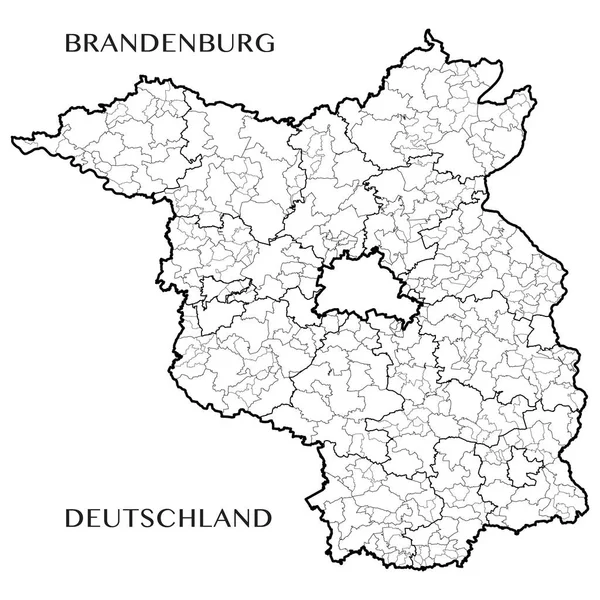
Detailed Map Of The State Of Brandenburg (Germany) With Borders Of Municipalities, Municipalities Associations, Districts, And State. Vector Illustration

Vector, 10.49MB, 5000 × 5000 eps
stock vector Switzerland provinces maps

Switzerland Provinces Maps

Vector, 6.96MB, 6000 × 4636 eps
stock vector map of germany with all cities over one hundred thousand inhabit

Map Of Germany With All Cities Over One Hundred Thousand Inhabit

Vector, 3.83MB, 5084 × 6505 eps
stock vector Slovakia provinces maps

Slovakia Provinces Maps

Vector, 1.46MB, 6000 × 4636 eps
stock vector Hungary provinces maps

Hungary Provinces Maps

Vector, 12.37MB, 6000 × 4636 eps
stock vector Georgia provinces maps

Georgia Provinces Maps

Vector, 6.31MB, 6000 × 4636 eps
stock image the Castle of St. George - a fortress within the boundaries of Lisbon, the historical core of the city.

The Castle Of St. George - A Fortress Within The Boundaries Of Lisbon, The Historical Core Of The City.

Image, 17.03MB, 5802 × 3868 jpg
stock vector administrative and political map of Germany newly revised 2019 in black and white

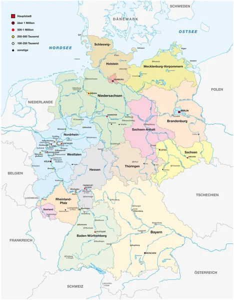
Administrative And Political Map Of Germany Newly Revised 2019 In Black And White

Vector, 7.28MB, 6258 × 8029 eps
stock vector Detailed map of the French region of Occitanie (France) with borders of municipalities, subdistricts (cantons), districts (arrondissements), departments (departements), and region

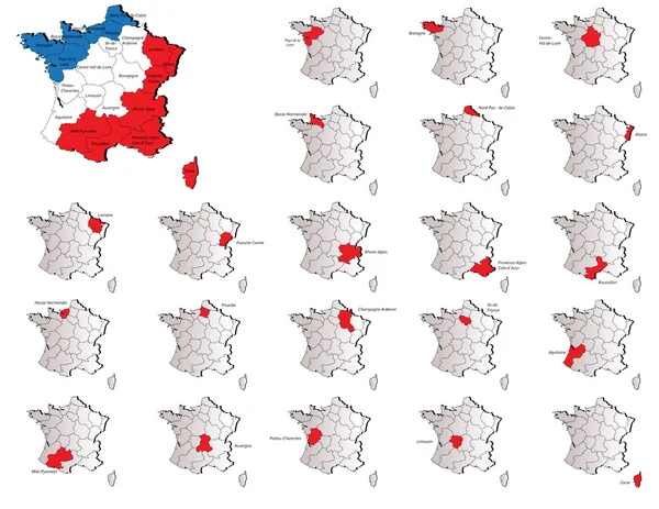
Detailed Map Of The French Region Of Occitanie (France) With Borders Of Municipalities, Subdistricts (cantons), Districts (arrondissements), Departments (departements), And Region

Vector, 9.27MB, 5000 × 5000 eps
stock vector Crete provinces maps

Crete Provinces Maps

Vector, 2.03MB, 6000 × 4636 eps
stock vector Turkey provinces maps

Turkey Provinces Maps

Vector, 1.5MB, 6000 × 4636 ai
stock image Gerrymandering mind map, concept for presentations and reports

Gerrymandering Mind Map, Concept For Presentations And Reports

Image, 3.89MB, 5760 × 3840 jpg
stock vector Belorrusia provinces maps

Belorrusia Provinces Maps

Vector, 1.38MB, 6000 × 4636 eps
stock vector italy region

Italy Region

Vector, 4.91MB, 5007 × 3540 ai
stock vector Spain maps

Spain Maps

Vector, 1.22MB, 3864 × 5000 eps
stock vector Detailed map of the Free State of Saxony (Germany) with borders of municipalities, municipalities associations, districts, and state. Vector illustration

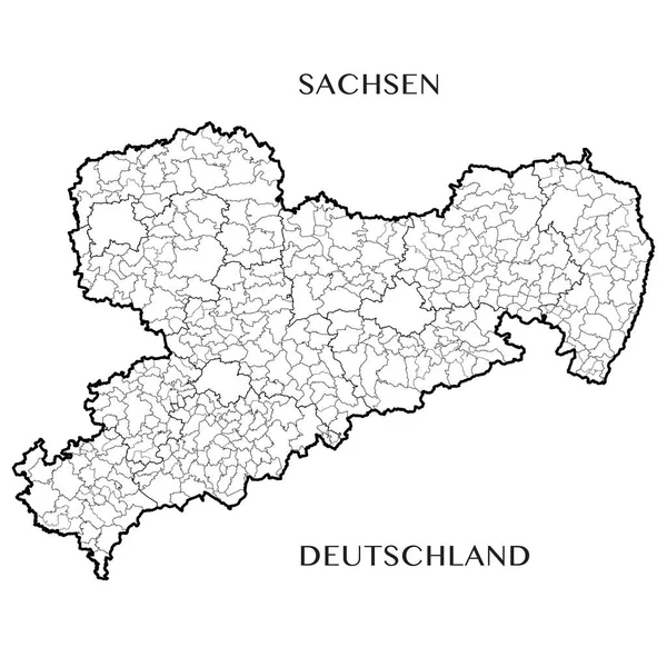
Detailed Map Of The Free State Of Saxony (Germany) With Borders Of Municipalities, Municipalities Associations, Districts, And State. Vector Illustration

Vector, 10.88MB, 5000 × 5000 eps
stock vector Malta maps

Malta Maps

Vector, 1.09MB, 6000 × 4636 eps
stock vector Guyana provinces maps

Guyana Provinces Maps

Vector, 4.73MB, 6000 × 4636 eps
stock vector France provinces maps

France Provinces Maps

Vector, 8.59MB, 6000 × 4636 eps
stock vector Uk provinces maps

Uk Provinces Maps

Vector, 3.57MB, 6000 × 4636 eps
stock vector Map of Saxony-Anhalt

Map Of Saxony-Anhalt

Vector, 0.12MB, 4000 × 4741 ai
Page 1 >> Next