photo free
Home Images Vectors Videos

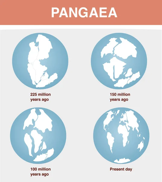
Stock image Continental Drift

stock vector Continental drift. Vector illustration of Pangaea, Laurasia, Gondwana, modern continents in flat style. The movement of mainlands on the planet Earth in different periods from 250 MYA to Present.

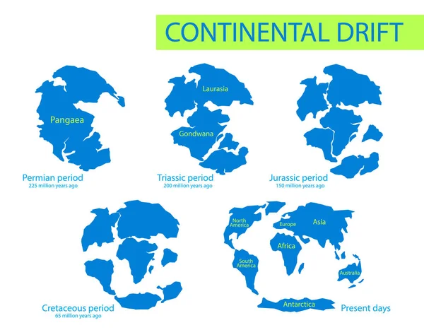
Continental Drift. Vector Illustration Of Pangaea, Laurasia, Gondwana, Modern Continents In Flat Style. The Movement Of Mainlands On The Planet Earth In Different Periods From 250 MYA To Present.

Vector, 1.41MB, 6418 × 5000 eps
stock vector Tectonic Plates PORTUGUESE NAMES

Tectonic Plates PORTUGUESE NAMES

Vector, 1.03MB, 9000 × 5495 eps
stock vector Continental drift. The movement of mainlands on the planet Earth in different periods from 250 MYA to Present. Vector illustration of Pangaea, Laurasia, Gondwana, modern continents in flat style

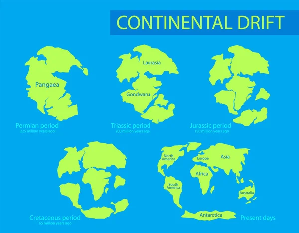
Continental Drift. The Movement Of Mainlands On The Planet Earth In Different Periods From 250 MYA To Present. Vector Illustration Of Pangaea, Laurasia, Gondwana, Modern Continents In Flat Style

Vector, 1.4MB, 6418 × 5000 eps
stock vector Tectonic Plates on the planet Earth. modern continents and   infographics Set of icons  Flat style

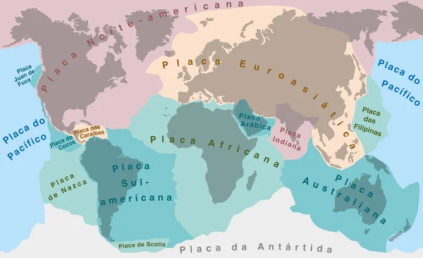
Tectonic Plates On The Planet Earth. Modern Continents And Infographics Set Of Icons Flat Style

Vector, 3.13MB, 5000 × 5000 eps
stock vector Continental drift on the planet Earth

Continental Drift On The Planet Earth

Vector, 2.48MB, 3957 × 4418 eps
stock vector Monochrome vector illustration silhouettes of Worldmap at Permian, Jurassic, Paleogen and Quartenary periods isolated on background. Continental drift and changes of Earth map.

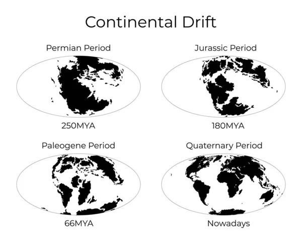
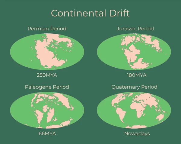
Monochrome Vector Illustration Silhouettes Of Worldmap At Permian, Jurassic, Paleogen And Quartenary Periods Isolated On Background. Continental Drift And Changes Of Earth Map.

Vector, 3.6MB, 6250 × 5000 eps
stock vector Silhouette of Map of the Earth 66MYA. Monochrome vector illustration of Earth map with black continents and white oceans isolated on white background. Projection. Prehistoric worldmap.

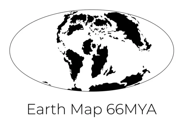
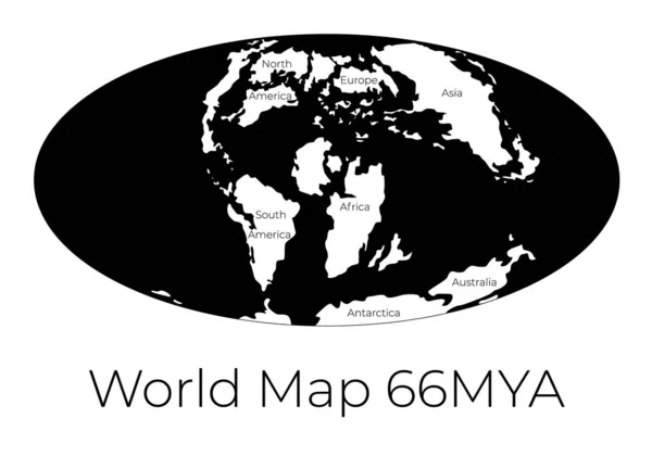
Silhouette Of Map Of The Earth 66MYA. Monochrome Vector Illustration Of Earth Map With Black Continents And White Oceans Isolated On White Background. Projection. Prehistoric Worldmap.

Vector, 0.98MB, 7143 × 5000 eps
stock vector Plate Tectonics FRENCH TERMS

Plate Tectonics FRENCH TERMS

Vector, 4.05MB, 9000 × 5495 eps
stock vector Plate Tectonics PORTUGUESE NAMES

Plate Tectonics PORTUGUESE NAMES

Vector, 4.05MB, 9000 × 5495 eps
stock image South American tectonic plate enlarged and extruded the global grayscale elevation map in the Azimuthal Equidistant projection with dashed plates borders. 3D rendering

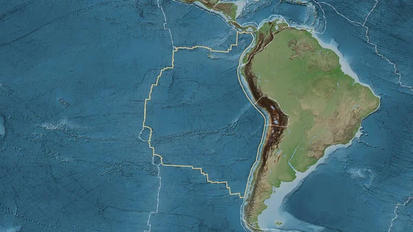
South American Tectonic Plate Enlarged And Extruded The Global Grayscale Elevation Map In The Azimuthal Equidistant Projection With Dashed Plates Borders. 3D Rendering

Image, 2.87MB, 2880 × 1620 jpg
stock image Pacific tectonic plate outlined on the global grayscale elevation map in the Kavrayskiy projection. 3D rendering

Pacific Tectonic Plate Outlined On The Global Grayscale Elevation Map In The Kavrayskiy Projection. 3D Rendering

Image, 2.65MB, 2880 × 1620 jpg
stock image Okinawa tectonic plate outlined on the globe. satellite imagery. 3D rendering

Okinawa Tectonic Plate Outlined On The Globe. Satellite Imagery. 3D Rendering

Image, 3.53MB, 2880 × 1620 jpg
stock image a dry path of sand in the australian outback ends in the desert

A Dry Path Of Sand In The Australian Outback Ends In The Desert

Image, 15.41MB, 6000 × 4000 jpg
stock image White mask of lands within areas adjacent to the Altiplano tectonic plate. Black background. Van der Grinten I projection (oblique transformation). Compositing tool

White Mask Of Lands Within Areas Adjacent To The Altiplano Tectonic Plate. Black Background. Van Der Grinten I Projection (oblique Transformation). Compositing Tool

Image, 0.09MB, 2880 × 1620 jpg
stock image Outline of the North Andes tectonic plate with the borders of surrounding plates against the background of a physical map. 3D rendering

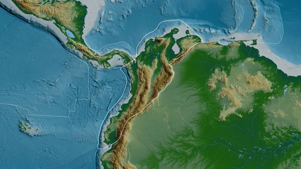
Outline Of The North Andes Tectonic Plate With The Borders Of Surrounding Plates Against The Background Of A Physical Map. 3D Rendering

Image, 4.76MB, 2880 × 1620 jpg
stock image Pattern map of the area around the Pacific tectonic plate. 3D rendering

Pattern Map Of The Area Around The Pacific Tectonic Plate. 3D Rendering

Image, 5.52MB, 2880 × 1620 jpg
stock vector Vector illustration of some basic lake types

Vector Illustration Of Some Basic Lake Types

Vector, 1.1MB, 3743 × 3200 eps
stock image Relief map of the area around the Pacific tectonic plate. 3D rendering

Relief Map Of The Area Around The Pacific Tectonic Plate. 3D Rendering

Image, 5.32MB, 2880 × 1620 jpg
stock vector Earth Structure White

Earth Structure White

Vector, 0.74MB, 9000 × 5344 eps
stock image Solomon Sea tectonic plate outlined on the global color physical map in the Kavrayskiy projection. 3D rendering

Solomon Sea Tectonic Plate Outlined On The Global Color Physical Map In The Kavrayskiy Projection. 3D Rendering

Image, 3.81MB, 2880 × 1620 jpg
stock vector Map of the World 66MYA. Monochrome vector illustration of Worldmap with white continents and black oceans isolated on white background. Prehistoric projection. Silhouette. Element for your design.

Map Of The World 66MYA. Monochrome Vector Illustration Of Worldmap With White Continents And Black Oceans Isolated On White Background. Prehistoric Projection. Silhouette. Element For Your Design.

Vector, 1.04MB, 7143 × 5000 eps
stock image Bridge between continents bottom view,Hafnir, Southern peninsula, Iceland.

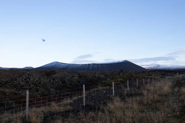
Bridge Between Continents Bottom View,Hafnir, Southern Peninsula, Iceland.

Image, 7.79MB, 4368 × 2912 jpg
stock image Silfra

Silfra

Image, 15.02MB, 5487 × 3660 jpg
stock vector Earth's Interior Black

Earth's Interior Black

Vector, 0.59MB, 9000 × 5549 eps
stock image Thingvellir, Iceland - July 19, 2017: Tourists walk through the Almannagja fault line in the mid-atlantic ridge north american plate in Thingvellir National Park. Iceland

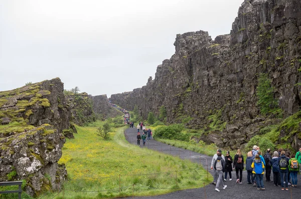
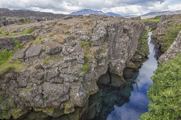
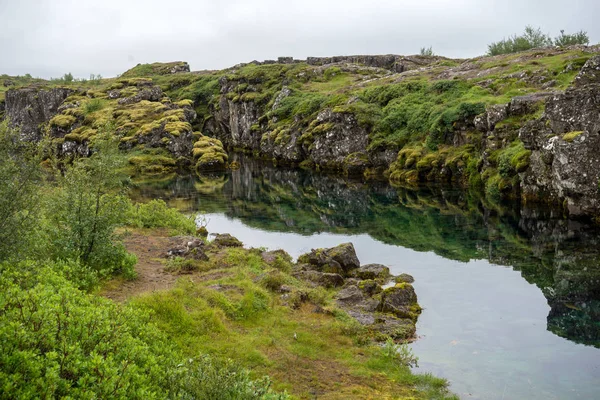
Thingvellir, Iceland - July 19, 2017: Tourists Walk Through The Almannagja Fault Line In The Mid-atlantic Ridge North American Plate In Thingvellir National Park. Iceland

Image, 13.83MB, 5644 × 3740 jpg
stock image Silfra

Silfra

Image, 16.46MB, 5472 × 3648 jpg
stock image Thingvellir rocks in Golden Circle of Iceland

Thingvellir Rocks In Golden Circle Of Iceland

Image, 13.22MB, 5184 × 3456 jpg
stock image Neighborhoods of the Aegean Sea tectonic plate on the relief map in the van der Grinten I projection (oblique transformation). Raw composite - no outlines

Neighborhoods Of The Aegean Sea Tectonic Plate On The Relief Map In The Van Der Grinten I Projection (oblique Transformation). Raw Composite - No Outlines

Image, 5.12MB, 2880 × 1620 jpg
stock image Tectonic plate interaction

Tectonic Plate Interaction

Image, 5.74MB, 6233 × 2986 jpg
stock image Relief map of the area around the Molucca Sea tectonic plate. 3D rendering

Relief Map Of The Area Around The Molucca Sea Tectonic Plate. 3D Rendering

Image, 4.05MB, 2880 × 1620 jpg
stock image Thingvellir rocks in Golden Circle of Iceland

Thingvellir Rocks In Golden Circle Of Iceland

Image, 7.58MB, 5184 × 3456 jpg
stock vector Silhouette of Map of the Earth 180MYA. Monochrome vector illustration of Earth map with black continents and white oceans isolated on white background. Projection. Prehistoric worldmap.

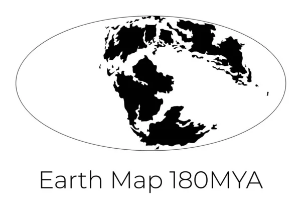
Silhouette Of Map Of The Earth 180MYA. Monochrome Vector Illustration Of Earth Map With Black Continents And White Oceans Isolated On White Background. Projection. Prehistoric Worldmap.

Vector, 1.07MB, 7143 × 5000 eps
stock vector Map of the World 180MYA. Monochrome vector illustration of Worldmap with white continents and black oceans isolated on white background. Prehistoric projection. Silhouette. Element for your design.

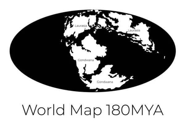
Map Of The World 180MYA. Monochrome Vector Illustration Of Worldmap With White Continents And Black Oceans Isolated On White Background. Prehistoric Projection. Silhouette. Element For Your Design.

Vector, 1MB, 7143 × 5000 eps
stock vector Continental drift and changes of Earth map. Colorful vector illustration of Worldmap at Permian, Jurassic, Paleogen and Quartenary periods isolated on background.

Continental Drift And Changes Of Earth Map. Colorful Vector Illustration Of Worldmap At Permian, Jurassic, Paleogen And Quartenary Periods Isolated On Background.

Vector, 3.62MB, 6250 × 5000 eps
stock vector Silhouette of Map of the Earth 230MYA. Monochrome vector illustration of Earth map with black continents and white oceans isolated on white background. Projection. Prehistoric worldmap.

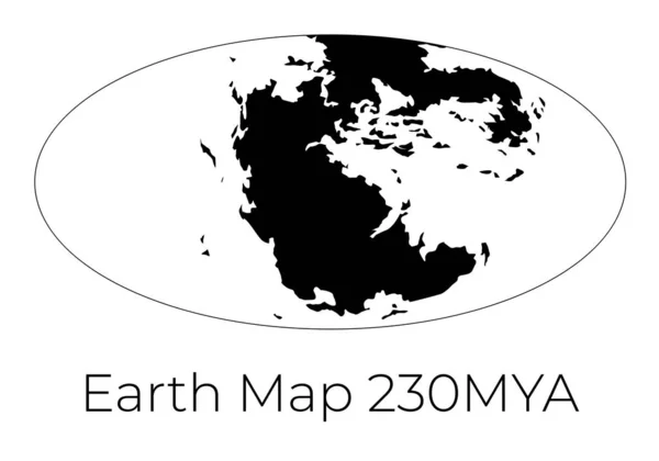
Silhouette Of Map Of The Earth 230MYA. Monochrome Vector Illustration Of Earth Map With Black Continents And White Oceans Isolated On White Background. Projection. Prehistoric Worldmap.

Vector, 0.93MB, 7143 × 5000 eps
stock image The Silfra fissure, ingvellir, where the European and American Plates meet. Thingvellir National Park near Reykjavik, Iceland .

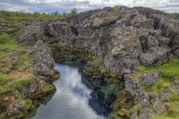
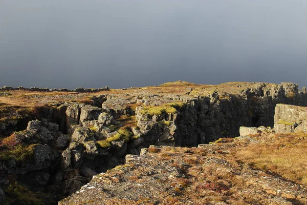
The Silfra Fissure, Ingvellir, Where The European And American Plates Meet. Thingvellir National Park Near Reykjavik, Iceland .

Image, 17.65MB, 6016 × 4016 jpg
stock image North American tectonic plate enlarged, extruded and rotated to the west side the global shapes only - land/ocean mask in the Azimuthal Equidistant projection with dashed plates borders. 3D rendering

North American Tectonic Plate Enlarged, Extruded And Rotated To The West Side The Global Shapes Only - Land/ocean Mask In The Azimuthal Equidistant Projection With Dashed Plates Borders. 3D Rendering

Image, 1.74MB, 2880 × 1620 jpg
stock image Africann tectonic plate overview the global grayscale elevation map in the Azimuthal Equidistant projection with dashed plates borders. 3D rendering

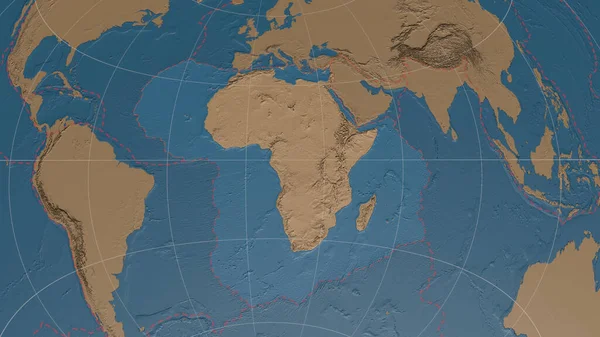
Africann Tectonic Plate Overview The Global Grayscale Elevation Map In The Azimuthal Equidistant Projection With Dashed Plates Borders. 3D Rendering

Image, 3.52MB, 2880 × 1620 jpg
stock vector Earths Inner Core

Earths Inner Core

Vector, 0.78MB, 6000 × 6000 eps
stock image Neighborhoods of the Caribbean tectonic plate on the grayscale map in the van der Grinten I projection (oblique transformation). Raw composite - no outlines

Neighborhoods Of The Caribbean Tectonic Plate On The Grayscale Map In The Van Der Grinten I Projection (oblique Transformation). Raw Composite - No Outlines

Image, 2.65MB, 2880 × 1620 jpg
stock image Area of the Nazca tectonic plate marked with a solid line on a pale colored elevation map in the Patterson Cylindrical projection

Area Of The Nazca Tectonic Plate Marked With A Solid Line On A Pale Colored Elevation Map In The Patterson Cylindrical Projection

Image, 7.51MB, 3840 × 2160 jpg
stock image Satellite imagery map of the world in the Patterson Cylindrical projection transformed to the center of the Rivera tectonic plate

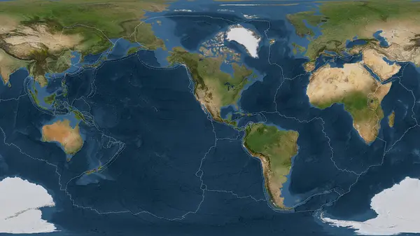
Satellite Imagery Map Of The World In The Patterson Cylindrical Projection Transformed To The Center Of The Rivera Tectonic Plate

Image, 6.56MB, 3840 × 2160 jpg
stock image Satellite map of the area around the Okinawa tectonic plate. 3D rendering

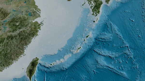
Satellite Map Of The Area Around The Okinawa Tectonic Plate. 3D Rendering

Image, 4.05MB, 2880 × 1620 jpg
stock image Physical map of the area around the North American tectonic plate. 3D rendering

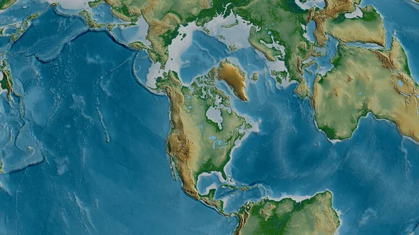
Physical Map Of The Area Around The North American Tectonic Plate. 3D Rendering

Image, 5.52MB, 2880 × 1620 jpg
stock image Antarctic tectonic plate overview the global shapes only - land/ocean mask in the Azimuthal Equidistant projection with dashed plates borders. 3D rendering

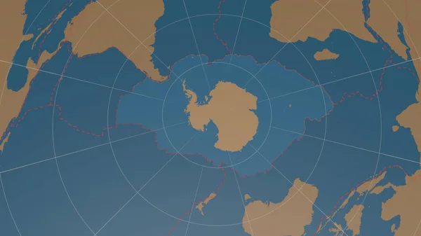
Antarctic Tectonic Plate Overview The Global Shapes Only - Land/ocean Mask In The Azimuthal Equidistant Projection With Dashed Plates Borders. 3D Rendering

Image, 1.56MB, 2880 × 1620 jpg
stock image Antarctica tectonic plate extruded on the globe. color physical map. 3D rendering

Antarctica Tectonic Plate Extruded On The Globe. Color Physical Map. 3D Rendering

Image, 3.72MB, 2880 × 1620 jpg
stock image Neighborhoods of the Panama tectonic plate on the bilevel elevation map in the van der Grinten I projection (oblique transformation). Raw composite - no outlines

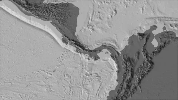
Neighborhoods Of The Panama Tectonic Plate On The Bilevel Elevation Map In The Van Der Grinten I Projection (oblique Transformation). Raw Composite - No Outlines

Image, 2.12MB, 2880 × 1620 jpg
stock image Neighborhoods of the Scotia tectonic plate on the physical map in the van der Grinten I projection (oblique transformation). Raw composite - no outlines

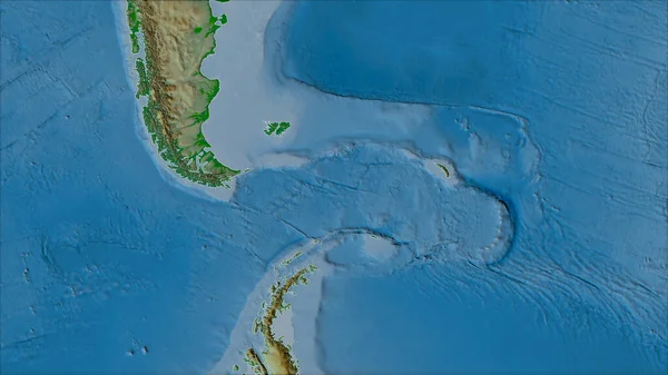
Neighborhoods Of The Scotia Tectonic Plate On The Physical Map In The Van Der Grinten I Projection (oblique Transformation). Raw Composite - No Outlines

Image, 3.92MB, 2880 × 1620 jpg
stock image Tectonic plates borders on the grayscale map of areas adjacent to the Caribbean plate area. Van der Grinten I projection (oblique transformation)

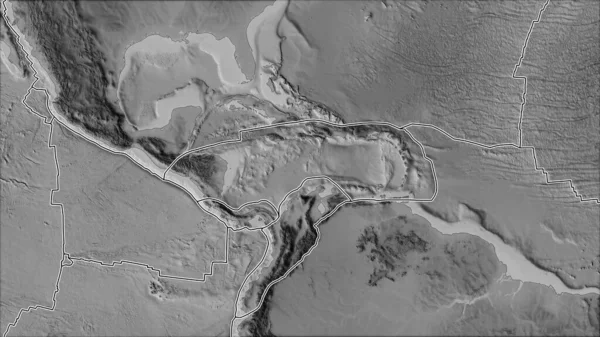
Tectonic Plates Borders On The Grayscale Map Of Areas Adjacent To The Caribbean Plate Area. Van Der Grinten I Projection (oblique Transformation)

Image, 2.7MB, 2880 × 1620 jpg
stock image Satellite map of the area around the Juan De Fuca tectonic plate. 3D rendering

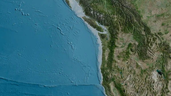
Satellite Map Of The Area Around The Juan De Fuca Tectonic Plate. 3D Rendering

Image, 5.02MB, 2880 × 1620 jpg
Page 1 >> Next