photo free
Home Images Vectors Videos

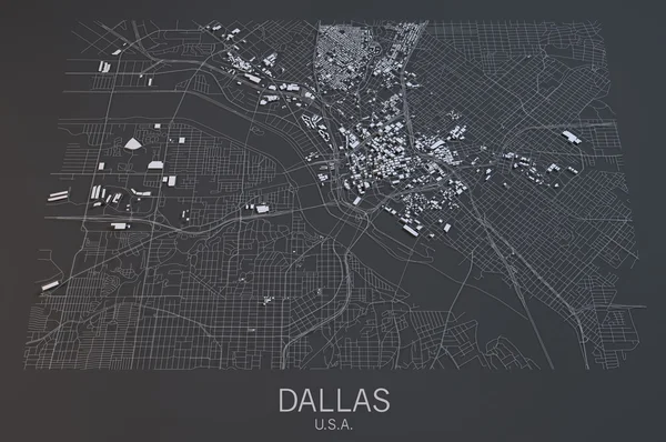
Stock image Satellite Map

stock vector Antenna blue and red four color minimal icon set

Antenna Blue And Red Four Color Minimal Icon Set

Vector, 0.01MB, 2401 × 2401 eps
stock image modern solar power satellite

Modern Solar Power Satellite

Image, 11.73MB, 5600 × 3733 jpg
stock vector Antenna four color glowing neon vector icon

Antenna Four Color Glowing Neon Vector Icon

Vector, 0.18MB, 2401 × 2401 eps
stock image Mobile GPS navigation concept. Smartphone on map of the city,

Mobile GPS Navigation Concept. Smartphone On Map Of The City,

Image, 11.77MB, 6000 × 4500 jpg
stock vector Antenna Green and yellow modern 3d vector icon logo

Antenna Green And Yellow Modern 3d Vector Icon Logo

Vector, 0.05MB, 2401 × 2401 eps
stock image satellite navigation concept

Satellite Navigation Concept

Image, 3.29MB, 5000 × 3750 jpg
stock vector Antenna blue gradient vector icon

Antenna Blue Gradient Vector Icon

Vector, 0MB, 2401 × 2401 eps
stock image Satellite map of Sevastopol, view from space. contains modified Copernicus Sentinel data

Satellite Map Of Sevastopol, View From Space. Contains Modified Copernicus Sentinel Data

Image, 3.72MB, 3000 × 2500 jpg
stock vector Antenna yellow glowing neon icon

Antenna Yellow Glowing Neon Icon

Vector, 0.01MB, 2401 × 2401 eps
stock image USA at night

USA At Night

Image, 9.18MB, 5000 × 3750 jpg
stock vector GPS navigation concept. Vector

GPS Navigation Concept. Vector

Vector, 2.84MB, 4000 × 4000 eps
stock image Planet Earth landforms

Planet Earth Landforms

Image, 10.68MB, 6500 × 6500 jpg
stock vector Earth background vector illustration

Earth Background Vector Illustration

Vector, 7.67MB, 4000 × 4000 eps
stock image World map on a technological background, glowing lines symbols of the Internet, radio, television, mobile and satellite communications. Elements of this image furnished by NASA

World Map On A Technological Background, Glowing Lines Symbols Of The Internet, Radio, Television, Mobile And Satellite Communications. Elements Of This Image Furnished By NASA

Image, 5.74MB, 5139 × 3432 jpg
stock vector Modern GPS, vector illustration

Modern GPS, Vector Illustration

Vector, 9.58MB, 4000 × 4000 eps
stock image GPS on smart phone

GPS On Smart Phone

Image, 4.62MB, 4928 × 3264 jpg
stock vector Antenna Flat four color minimal icon set

Antenna Flat Four Color Minimal Icon Set

Vector, 0.01MB, 2401 × 2401 eps
stock image Navigation

Navigation

Image, 2.43MB, 3000 × 2250 jpg
stock vector Antenna four color glass button icon

Antenna Four Color Glass Button Icon

Vector, 1.12MB, 2401 × 2401 eps
stock image Map of Paris, France

Map Of Paris, France

Image, 17.82MB, 4409 × 3307 jpg
stock vector Antenna silver plated metallic icon

Antenna Silver Plated Metallic Icon

Vector, 0.01MB, 2401 × 2401 eps
stock image Planet Earth landforms

Planet Earth Landforms

Image, 9.16MB, 6500 × 6500 jpg
stock vector Antenna minimal bright yellow material icon

Antenna Minimal Bright Yellow Material Icon

Vector, 0.01MB, 2401 × 2401 eps
stock vector Vector world map connection

Vector World Map Connection

Vector, 6.06MB, 5000 × 3028 eps
stock vector Antenna golden line premium logo or icon

Antenna Golden Line Premium Logo Or Icon

Vector, 0.01MB, 2401 × 2401 eps
stock image Dallas satellite map view

Dallas Satellite Map View

Image, 7.1MB, 4473 × 2970 jpg
stock vector Antenna gold plated metalic icon or logo vector

Antenna Gold Plated Metalic Icon Or Logo Vector

Vector, 0.01MB, 2401 × 2401 eps
stock vector Satellite map of Murcia, it is a city in south-eastern Spain, the capital and most populous city of the Autonomous Community of the Region of Murcia. Map of streets and buildings of the town center. Europe

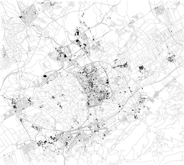
Satellite Map Of Murcia, It Is A City In South-eastern Spain, The Capital And Most Populous City Of The Autonomous Community Of The Region Of Murcia. Map Of Streets And Buildings Of The Town Center. Europe

Vector, 8MB, 7773 × 7003 eps
stock vector Satellite map of Province of Ferrara towns and roads, buildings and connecting roads of surrounding areas. Emilia-Romagna region, Italy. Map roads, ring roads

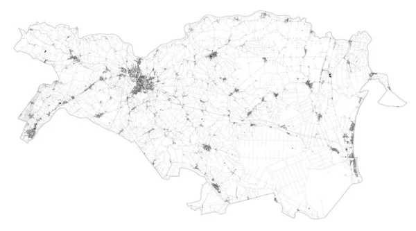
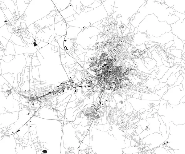
Satellite Map Of Province Of Ferrara Towns And Roads, Buildings And Connecting Roads Of Surrounding Areas. Emilia-Romagna Region, Italy. Map Roads, Ring Roads

Vector, 24.21MB, 8024 × 4458 eps
stock vector Satellite map of Memphis, Tennessee, Usa, city streets. Street map and map of the city center

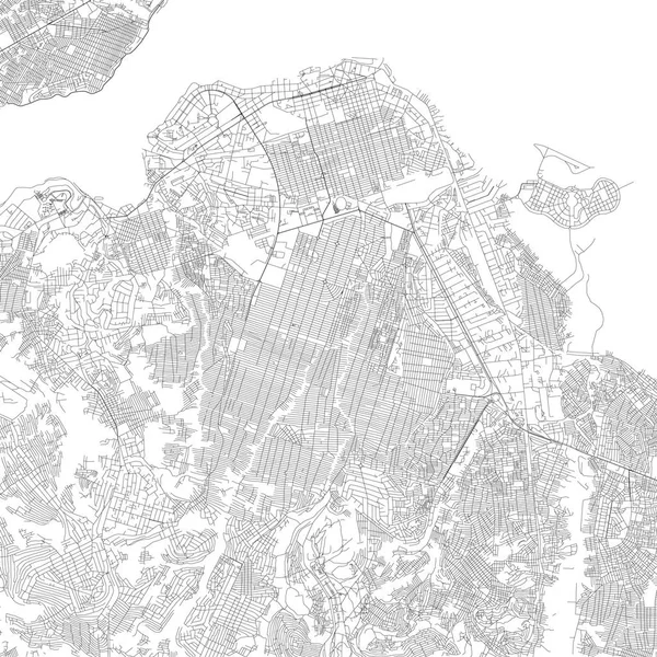
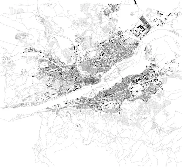
Satellite Map Of Memphis, Tennessee, Usa, City Streets. Street Map And Map Of The City Center

Vector, 3.32MB, 9634 × 5992 eps
stock vector Satellite map of Samarkand, alternatively Samarqand, it is a city in south-eastern Uzbekistan and one of the oldest continuously inhabited cities in Central Asia. Map of streets and buildings of the town center

Satellite Map Of Samarkand, Alternatively Samarqand, It Is A City In South-eastern Uzbekistan And One Of The Oldest Continuously Inhabited Cities In Central Asia. Map Of Streets And Buildings Of The Town Center

Vector, 4.38MB, 10659 × 8325 eps
stock vector Satellite map of Kinshasa (Leopoldville), is the capital and the largest city of the Democratic Republic of the Congo. Streets map and city center.

Satellite Map Of Kinshasa (Leopoldville), Is The Capital And The Largest City Of The Democratic Republic Of The Congo. Streets Map And City Center.

Vector, 4.71MB, 4717 × 4717 eps
stock vector Satellite map, Pristina, is the capital of Kosovo. Map of streets and buildings of the town center

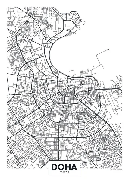
Satellite Map, Pristina, Is The Capital Of Kosovo. Map Of Streets And Buildings Of The Town Center

Vector, 5.74MB, 3973 × 3319 eps
stock vector Detailed vector poster city map Doha

Detailed Vector Poster City Map Doha

Vector, 2.8MB, 4218 × 5906 eps
stock vector Satellite map of N'Djamena, Chad, city streets. Street map, city center. Africa

Satellite Map Of N'Djamena, Chad, City Streets. Street Map, City Center. Africa

Vector, 11.12MB, 9684 × 5992 eps
stock vector Satellite map of Aden, it is a port city of Yemen, located by the eastern approach to the Red Sea, Aden's natural harbour lies in the crater of a dormant volcano. Map of streets and buildings of the town center

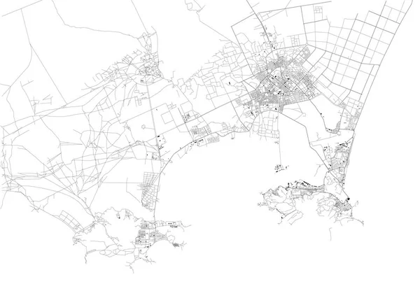
Satellite Map Of Aden, It Is A Port City Of Yemen, Located By The Eastern Approach To The Red Sea, Aden's Natural Harbour Lies In The Crater Of A Dormant Volcano. Map Of Streets And Buildings Of The Town Center

Vector, 3.43MB, 8429 × 5992 eps
stock vector Satellite map of Abuja, Nigeria, city streets. Street map, city center. Africa

Satellite Map Of Abuja, Nigeria, City Streets. Street Map, City Center. Africa

Vector, 4.67MB, 10409 × 5992 eps
stock vector Satellite map of Wuhan, Jiang an District, Hubei, China towns and roads, buildings and connecting roads. Map. Coronavirus

Satellite Map Of Wuhan, Jiang An District, Hubei, China Towns And Roads, Buildings And Connecting Roads. Map. Coronavirus

Vector, 11.78MB, 4093 × 4661 eps
stock vector Satellite map of Kuala Lumpur, Malaysia, city streets. Street map and map of the city center

Satellite Map Of Kuala Lumpur, Malaysia, City Streets. Street Map And Map Of The City Center

Vector, 8.38MB, 9844 × 5993 eps
stock vector Satellite map of Krasnoyarsk, Siberia, Russia. It is a city and the administrative center of Krasnoyarsk Krai, Russia, located on the Yenisei River. Map of streets and buildings of the town center. Asia

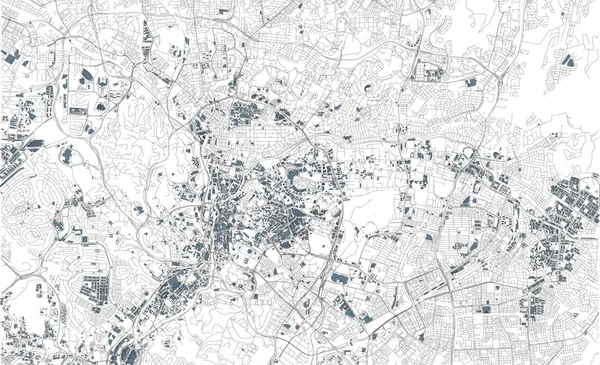
Satellite Map Of Krasnoyarsk, Siberia, Russia. It Is A City And The Administrative Center Of Krasnoyarsk Krai, Russia, Located On The Yenisei River. Map Of Streets And Buildings Of The Town Center. Asia

Vector, 20.73MB, 7087 × 6480 eps
stock vector Satellite map of Bishkek formerly Pishpek and Frunze, it is the capital and largest city of Kyrgyzstan. Map of streets and buildings of the town center

Satellite Map Of Bishkek Formerly Pishpek And Frunze, It Is The Capital And Largest City Of Kyrgyzstan. Map Of Streets And Buildings Of The Town Center

Vector, 18.55MB, 7561 × 5665 eps
stock vector Satellite map of Province of Crotone towns and roads, buildings and connecting roads of surrounding areas. Calabria region, Italy. Map roads, ring roads

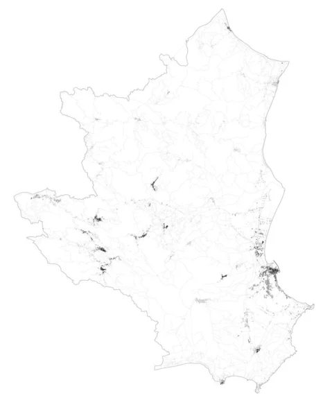
Satellite Map Of Province Of Crotone Towns And Roads, Buildings And Connecting Roads Of Surrounding Areas. Calabria Region, Italy. Map Roads, Ring Roads

Vector, 11.08MB, 4916 × 6144 eps
stock image High resolution world map focused on North America

High Resolution World Map Focused On North America

Image, 13.09MB, 6810 × 4541 jpg
stock image GPS satellite. Flat 3d illustration. Wireless satellite technology. World global net.

GPS Satellite. Flat 3d Illustration. Wireless Satellite Technology. World Global Net.

Image, 2.15MB, 3746 × 3000 jpg
stock vector Satellite map of Nashville, Tennessee, Usa, city streets. Street map and map of the city center.

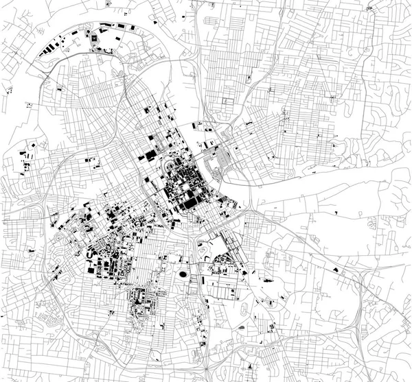
Satellite Map Of Nashville, Tennessee, Usa, City Streets. Street Map And Map Of The City Center.

Vector, 3.08MB, 6454 × 5992 eps
stock vector Satellite map of Agra, India.It is a city on the banks of the Yamuna river in the Indian state of Uttar Pradesh. Map of streets and buildings of the town center

Satellite Map Of Agra, India.It Is A City On The Banks Of The Yamuna River In The Indian State Of Uttar Pradesh. Map Of Streets And Buildings Of The Town Center

Vector, 7.35MB, 11467 × 8912 eps
stock vector Satellite map of Ho Chi Minh, Vietnam, city streets. Street map, city center. Asia

Satellite Map Of Ho Chi Minh, Vietnam, City Streets. Street Map, City Center. Asia

Vector, 13.52MB, 7551 × 7951 eps
stock vector Satellite map of Province of Viterbo towns and roads, buildings and connecting roads of surrounding areas. Lazio region, Italy. Map roads, ring roads

Satellite Map Of Province Of Viterbo Towns And Roads, Buildings And Connecting Roads Of Surrounding Areas. Lazio Region, Italy. Map Roads, Ring Roads

Vector, 15.41MB, 7369 × 6565 eps
stock vector Satellite map of Cairo, it is the capital of Egypt, associated with ancient Egypt, as the famous Giza pyramid complex. The city is situated on the Nile river. Map of streets and buildings of the town center.

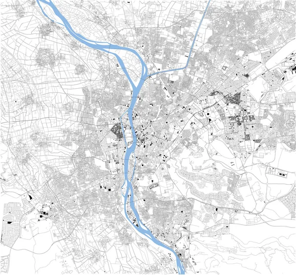
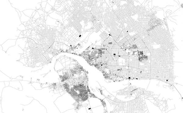
Satellite Map Of Cairo, It Is The Capital Of Egypt, Associated With Ancient Egypt, As The Famous Giza Pyramid Complex. The City Is Situated On The Nile River. Map Of Streets And Buildings Of The Town Center.

Vector, 20.37MB, 7087 × 6596 eps
stock vector Flat 3d isometric mobile GPS navigation maps infographic concept vector

Flat 3d Isometric Mobile GPS Navigation Maps Infographic Concept Vector

Vector, 0.33MB, 5333 × 4000 eps
Page 1 >> Next