photo free
Home Images Vectors Videos

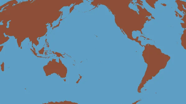
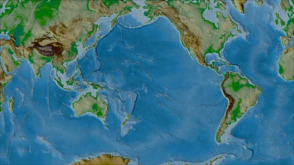
Stock image Pacific Tectonic Plate

stock image Relief map of the area around the Pacific tectonic plate. 3D rendering

Relief Map Of The Area Around The Pacific Tectonic Plate. 3D Rendering

Image, 5.32MB, 2880 × 1620 jpg
stock image Pacific tectonic plate outlined on the global grayscale elevation map in the Kavrayskiy projection. 3D rendering

Pacific Tectonic Plate Outlined On The Global Grayscale Elevation Map In The Kavrayskiy Projection. 3D Rendering

Image, 2.65MB, 2880 × 1620 jpg
stock image Pattern map of the area around the Pacific tectonic plate. 3D rendering

Pattern Map Of The Area Around The Pacific Tectonic Plate. 3D Rendering

Image, 5.52MB, 2880 × 1620 jpg
stock vector Tectonic Plates Earth

Tectonic Plates Earth

Vector, 0.96MB, 9000 × 5495 eps
stock vector Map of Earth's principal tectonic plates. Earth's lithosphere. Major and minor plates. arrows indicate direction of movement at plate boundaries. Vector illustration

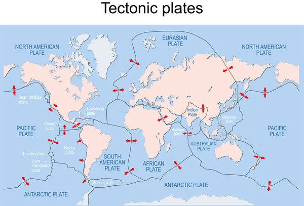
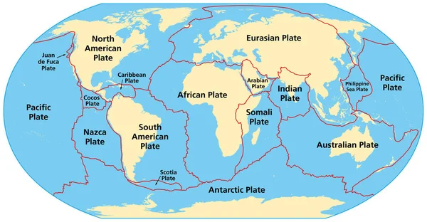
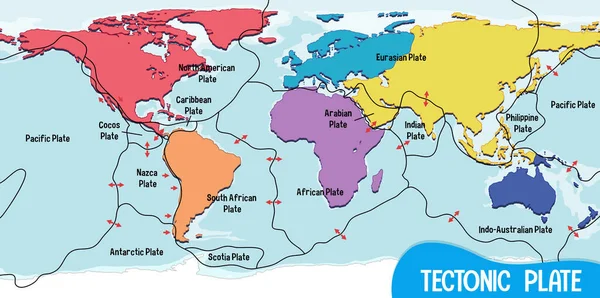
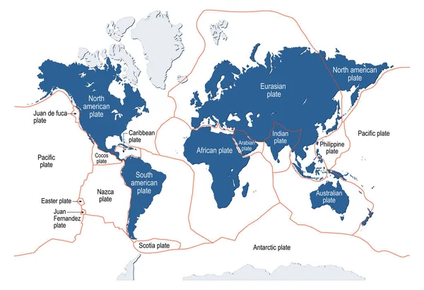
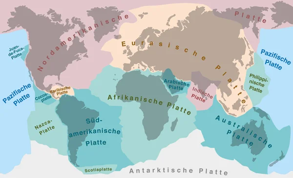
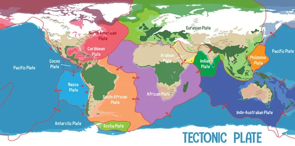
Map Of Earth's Principal Tectonic Plates. Earth's Lithosphere. Major And Minor Plates. Arrows Indicate Direction Of Movement At Plate Boundaries. Vector Illustration

Vector, 3.61MB, 11775 × 7995 eps
stock image Satellite map of the area around the Pacific tectonic plate. 3D rendering

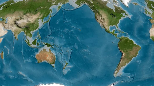
Satellite Map Of The Area Around The Pacific Tectonic Plate. 3D Rendering

Image, 5.12MB, 2880 × 1620 jpg
stock vector World Map Showing Tectonic Plates Boundaries illustration

World Map Showing Tectonic Plates Boundaries Illustration

Vector, 2.39MB, 7071 × 3457 eps
stock image Outline of the Pacific tectonic plate with the borders of surrounding plates against the background of a relief map. 3D rendering

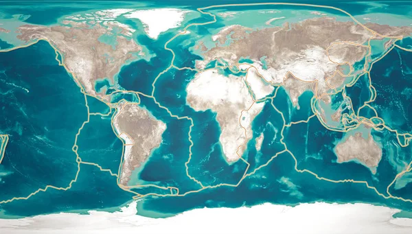
Outline Of The Pacific Tectonic Plate With The Borders Of Surrounding Plates Against The Background Of A Relief Map. 3D Rendering

Image, 5.55MB, 2880 × 1620 jpg
stock vector Map of the principal tectonic plates of the Earth. The sixteen major pieces of crust and uppermost mantle of the Earth, called the lithosphere, and consisting of oceanic and continental crust. Vector

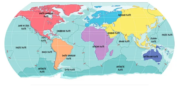
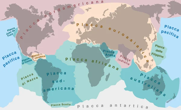
Map Of The Principal Tectonic Plates Of The Earth. The Sixteen Major Pieces Of Crust And Uppermost Mantle Of The Earth, Called The Lithosphere, And Consisting Of Oceanic And Continental Crust. Vector

Vector, 4.27MB, 9000 × 4681 eps
stock vector illustration of japan trench diagram

Illustration Of Japan Trench Diagram

Vector, 6.89MB, 10000 × 6759 eps
stock vector Principal tectonic plates of the Earth, world map. The sixteen major pieces of crust and uppermost mantle of the Earth, called the lithosphere, and consisting of oceanic and continental crust. Vector

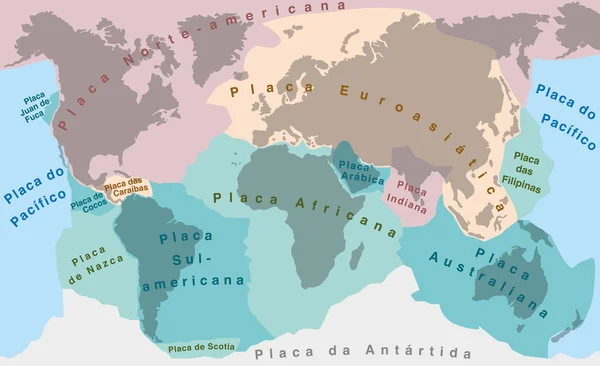
Principal Tectonic Plates Of The Earth, World Map. The Sixteen Major Pieces Of Crust And Uppermost Mantle Of The Earth, Called The Lithosphere, And Consisting Of Oceanic And Continental Crust. Vector

Vector, 7.85MB, 9000 × 4681 eps
stock vector World Map Showing Tectonic Plates Boundaries illustration

World Map Showing Tectonic Plates Boundaries Illustration

Vector, 2.05MB, 6599 × 3367 eps
stock vector Planet earth before and after

Planet Earth Before And After

Vector, 1.29MB, 5000 × 3032 eps
stock vector Tsunami warning system. Vector design, Illustration.

Tsunami Warning System. Vector Design, Illustration.

Vector, 1.93MB, 6063 × 6063 eps
stock image Tectonic plates move constantly, making new areas of ocean floor, building mountains, causing earthquakes, and creating volcanoes. 3d rendering. Map. Element of this image are furnished by Nasa

Tectonic Plates Move Constantly, Making New Areas Of Ocean Floor, Building Mountains, Causing Earthquakes, And Creating Volcanoes. 3d Rendering. Map. Element Of This Image Are Furnished By Nasa

Image, 16.33MB, 6675 × 3800 jpg
stock image Neighborhoods of the Pacific tectonic plate on the physical map in the van der Grinten I projection (oblique transformation). Raw composite - no outlines

Neighborhoods Of The Pacific Tectonic Plate On The Physical Map In The Van Der Grinten I Projection (oblique Transformation). Raw Composite - No Outlines

Image, 6.81MB, 2880 × 1620 jpg
stock image Tectonic plates move constantly, making new areas of ocean floor, building mountains, causing earthquakes, and creating volcanoes. 3d rendering. Map. Element of this image are furnished by Nasa

Tectonic Plates Move Constantly, Making New Areas Of Ocean Floor, Building Mountains, Causing Earthquakes, And Creating Volcanoes. 3d Rendering. Map. Element Of This Image Are Furnished By Nasa

Image, 9.22MB, 5014 × 5010 jpg
stock image earth without water and plants,pacific. along the tectonic plates cracks with ascending magma.

Earth Without Water And Plants,pacific. Along The Tectonic Plates Cracks With Ascending Magma.

Image, 0MB, 4000 × 4000 jpg
stock vector Pangaea

Pangaea

Vector, 1MB, 5000 × 6138 eps
stock vector World Map Showing Tectonic Plates Boundaries illustration

World Map Showing Tectonic Plates Boundaries Illustration

Vector, 1.95MB, 6683 × 3325 eps
stock vector Tectonic Plates PORTUGUESE NAMES

Tectonic Plates PORTUGUESE NAMES

Vector, 1.03MB, 9000 × 5495 eps
stock vector The ocean current world map with names illustration

The Ocean Current World Map With Names Illustration

Vector, 2.04MB, 7358 × 3297 eps
stock vector Tectonic Plates ITALIAN LABELING

Tectonic Plates ITALIAN LABELING

Vector, 1.04MB, 9000 × 5495 eps
stock vector Tectonic plate. Earth's lithosphere. scientific theory. world map with major an minor plates. Vector illustration.

Tectonic Plate. Earth's Lithosphere. Scientific Theory. World Map With Major An Minor Plates. Vector Illustration.

Vector, 3.69MB, 5570 × 3811 eps
stock vector Continental Drift Tectonic Plates German

Continental Drift Tectonic Plates German

Vector, 0.99MB, 9000 × 5495 eps
stock vector Tectonic Plates SPANISH TEXT

Tectonic Plates SPANISH TEXT

Vector, 1.01MB, 9000 × 5495 eps
stock vector The ocean current world map with names illustration

The Ocean Current World Map With Names Illustration

Vector, 2.06MB, 6683 × 3325 eps
stock vector Pangaea school globe

Pangaea School Globe

Vector, 1.34MB, 5000 × 5585 eps
stock vector The ocean current world map with names illustration

The Ocean Current World Map With Names Illustration

Vector, 1.94MB, 6683 × 3325 eps
stock vector The ocean current world map with names illustration

The Ocean Current World Map With Names Illustration

Vector, 1.94MB, 6662 × 3335 eps
stock vector The ocean current world map with names illustration

The Ocean Current World Map With Names Illustration

Vector, 1.94MB, 6662 × 3335 eps
stock vector Vector illustration of the San Andreas Fault and Now Entering Pacific Plate brown road signs

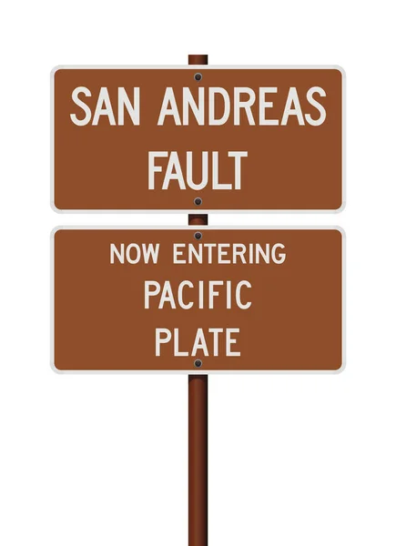
Vector Illustration Of The San Andreas Fault And Now Entering Pacific Plate Brown Road Signs

Vector, 1.14MB, 6173 × 8500 ai
stock vector World Map Showing Tectonic Plates Boundaries illustration

World Map Showing Tectonic Plates Boundaries Illustration

Vector, 1.39MB, 6683 × 3325 eps
stock vector vector illustration of a tsunami background

Vector Illustration Of A Tsunami Background

Vector, 0MB, 4536 × 4536 zip
stock vector The ocean current world map illustration

The Ocean Current World Map Illustration

Vector, 2.18MB, 6662 × 3335 eps
stock image View of Abbotsford, Canada, BC, with Mt. Baker in the background

View Of Abbotsford, Canada, BC, With Mt. Baker In The Background

Image, 9.81MB, 4928 × 3264 jpg
stock image Snow covered peaks of Mt. Baker visible from Abbotsford, BC, Canada

Snow Covered Peaks Of Mt. Baker Visible From Abbotsford, BC, Canada

Image, 10.65MB, 4928 × 3264 jpg
stock image Divergent plate boundary with explanation, tectonic boundaries, ocean ridge cross section, Divergent tectonic plate boundary,plate boundary earthquake

Divergent Plate Boundary With Explanation, Tectonic Boundaries, Ocean Ridge Cross Section, Divergent Tectonic Plate Boundary,plate Boundary Earthquake

Image, 0.52MB, 4800 × 2700 jpg
stock image Map of Earth's principal tectonic plates, Tectonic Plate World Map Concept Design, The sixteen major pieces of crust and uppermost mantle of the Earth, called the lithosphere, Earth's surface, geology

Map Of Earth's Principal Tectonic Plates, Tectonic Plate World Map Concept Design, The Sixteen Major Pieces Of Crust And Uppermost Mantle Of The Earth, Called The Lithosphere, Earth's Surface, Geology

Image, 1.06MB, 4800 × 2700 jpg
stock image View of Abbotsford, Canada, BC from Highstreet

View Of Abbotsford, Canada, BC From Highstreet

Image, 15.51MB, 4928 × 3264 jpg
stock image Snow covered peaks of Mt. Baker visible from Abbotsford, BC, Canada

Snow Covered Peaks Of Mt. Baker Visible From Abbotsford, BC, Canada

Image, 11.99MB, 4928 × 3264 jpg
stock vector Illustration of Earth's major tectonic plates

Illustration Of Earth's Major Tectonic Plates

Vector, 4.56MB, 6284 × 3535 eps
stock image Tectonic plates borders on the physical map of areas adjacent to the Pacific plate area. Van der Grinten I projection (oblique transformation)

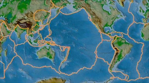
Tectonic Plates Borders On The Physical Map Of Areas Adjacent To The Pacific Plate Area. Van Der Grinten I Projection (oblique Transformation)

Image, 7.14MB, 2880 × 1620 jpg
stock image Snow covered peaks of Mt. Baker visible from Abbotsford, BC, Canada

Snow Covered Peaks Of Mt. Baker Visible From Abbotsford, BC, Canada

Image, 6.75MB, 4928 × 3264 jpg
stock image Divergent plate boundary with explanation, Volcanic Eruption Process, Volcano Activity at Subduction Zone, Volcanic mountains, Plate boundaries, Labeled tectonic movement comparison, earthquake

Divergent Plate Boundary With Explanation, Volcanic Eruption Process, Volcano Activity At Subduction Zone, Volcanic Mountains, Plate Boundaries, Labeled Tectonic Movement Comparison, Earthquake

Image, 0.49MB, 4800 × 2700 jpg
stock image Snow covered peaks of Mt. Baker Mt. Baker seen from a gap in the pine trees

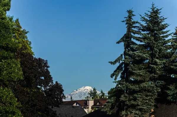
Snow Covered Peaks Of Mt. Baker Mt. Baker Seen From A Gap In The Pine Trees

Image, 8.92MB, 4776 × 3163 jpg
stock image Snow covered peaks of Mt. Baker visible from Abbotsford, BC, Canada

Snow Covered Peaks Of Mt. Baker Visible From Abbotsford, BC, Canada

Image, 8.32MB, 4928 × 3264 jpg
Page 1 >> Next