photo free
Home Images Vectors Videos

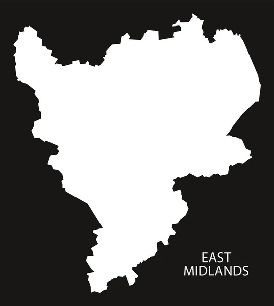
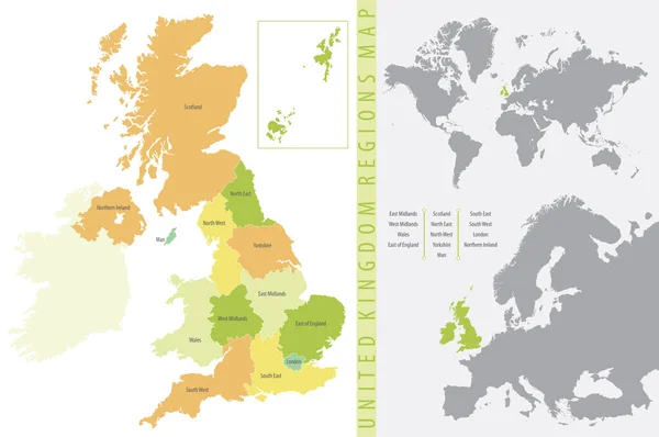
Stock image Midlands Region

stock image The Liffey Falls, a series of four distinct tiered cascade waterfalls on the Liffey River, is located in the Midlands region of Tasmania, Australia.

The Liffey Falls, A Series Of Four Distinct Tiered Cascade Waterfalls On The Liffey River, Is Located In The Midlands Region Of Tasmania, Australia.

Image, 4.2MB, 3166 × 2111 jpg
stock image The Liffey Falls, a series of four distinct tiered cascade waterfalls on the Liffey River, is located in the Midlands region of Tasmania, Australia.

The Liffey Falls, A Series Of Four Distinct Tiered Cascade Waterfalls On The Liffey River, Is Located In The Midlands Region Of Tasmania, Australia.

Image, 5.25MB, 2336 × 3504 jpg
stock image Liffey Falls State Reserve at the Midlands region of Tasmania, Australia.

Liffey Falls State Reserve At The Midlands Region Of Tasmania, Australia.

Image, 7.09MB, 3504 × 2336 jpg
stock image The Liffey Falls, a series of four distinct tiered cascade waterfalls on the Liffey River, is located in the Midlands region of Tasmania, Australia.

The Liffey Falls, A Series Of Four Distinct Tiered Cascade Waterfalls On The Liffey River, Is Located In The Midlands Region Of Tasmania, Australia.

Image, 5.01MB, 3504 × 2336 jpg
stock image The Liffey Falls, a series of four distinct tiered cascade waterfalls on the Liffey River, is located in the Midlands region of Tasmania, Australia.

The Liffey Falls, A Series Of Four Distinct Tiered Cascade Waterfalls On The Liffey River, Is Located In The Midlands Region Of Tasmania, Australia.

Image, 5.75MB, 3504 × 2336 jpg
stock image Liffey Falls State Reserve at the Midlands region of Tasmania, Australia.

Liffey Falls State Reserve At The Midlands Region Of Tasmania, Australia.

Image, 5.69MB, 3504 × 2336 jpg
stock image Flag of County Offaly is a county in Ireland

Flag Of County Offaly Is A County In Ireland

Image, 1.02MB, 3072 × 1920 jpg
stock vector West Midlands England Map black inverted

West Midlands England Map Black Inverted

Vector, 4.65MB, 5000 × 5546 eps
stock image A view along the sun drenched side of the Corby Viaduct on the outskirts of Corby, Northampton, UK on a bright winters day

A View Along The Sun Drenched Side Of The Corby Viaduct On The Outskirts Of Corby, Northampton, UK On A Bright Winters Day

Image, 4.72MB, 2900 × 1929 jpg
stock image Traditional African landscape scene with a feeding Nguni cow and a small village with mud huts in the background image with copy space in landscape format

Traditional African Landscape Scene With A Feeding Nguni Cow And A Small Village With Mud Huts In The Background Image With Copy Space In Landscape Format

Image, 8.13MB, 5471 × 3198 jpg
stock image A view down the boating lake in the central park in Corby, Northampton, UK on a bright winters day

A View Down The Boating Lake In The Central Park In Corby, Northampton, UK On A Bright Winters Day

Image, 5.1MB, 2900 × 1929 jpg
stock vector Coat of arms of Worcestershire in England

Coat Of Arms Of Worcestershire In England

Vector, 3.58MB, 4088 × 5966 eps
stock image East Midlands England UK Art Map

East Midlands England UK Art Map

Image, 30.8MB, 5000 × 5891 jpg
stock image Amphitheater at Royal Natal National Park in the Drakensberg Mountains, South Africa

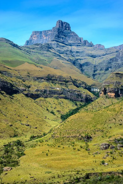
Amphitheater At Royal Natal National Park In The Drakensberg Mountains, South Africa

Image, 14.73MB, 3514 × 5264 jpg
stock image West Midlands flag

West Midlands Flag

Image, 0.99MB, 5962 × 3948 jpg
stock image An aerial view above the Corby Viaduct and dual carriageway on the outskirts of Corby, Northampton, UK on a bright winters day

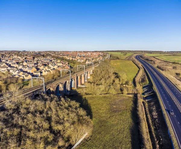
An Aerial View Above The Corby Viaduct And Dual Carriageway On The Outskirts Of Corby, Northampton, UK On A Bright Winters Day

Image, 4.24MB, 2475 × 2041 jpg
stock vector Leicester Downtown Vector Map

Leicester Downtown Vector Map

Vector, 5.24MB, 8000 × 8000 eps
stock vector England ceremonial counties vector map colored by regions

England Ceremonial Counties Vector Map Colored By Regions

Vector, 6.62MB, 7293 × 6736 eps
stock vector Flag of Worcestershire in England

Flag Of Worcestershire In England

Vector, 5.18MB, 8334 × 5534 eps
stock vector Coat of arms of Rutland in England

Coat Of Arms Of Rutland In England

Vector, 4.18MB, 3937 × 6010 eps
stock vector Map of West Midlands England

Map Of West Midlands England

Vector, 9.21MB, 7006 × 6706 eps
stock vector East Midlands England Map black inverted

East Midlands England Map Black Inverted

Vector, 5.21MB, 5000 × 5585 eps
stock vector vector map of United Kingdom colored by countries, counties and regions

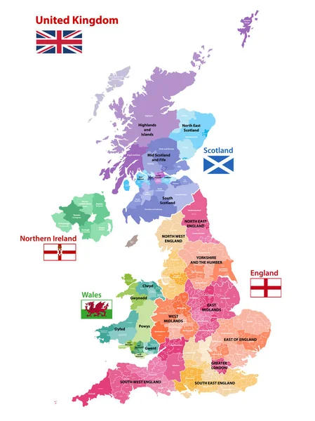
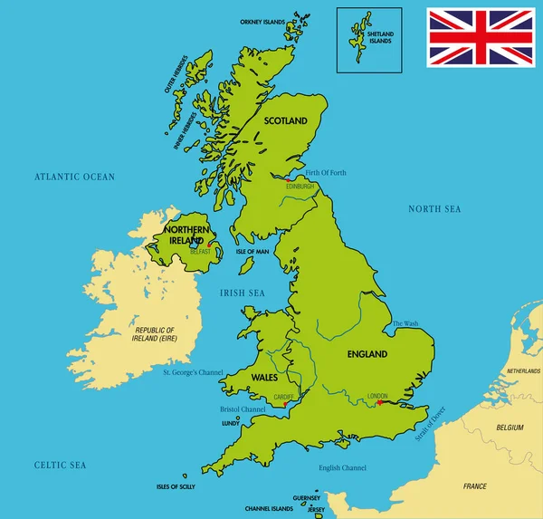
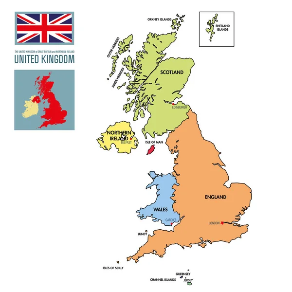
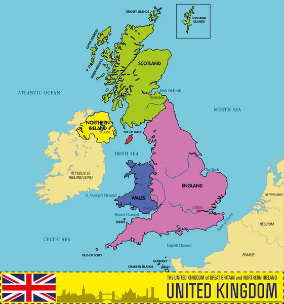
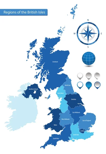
Vector Map Of United Kingdom Colored By Countries, Counties And Regions

Vector, 10.75MB, 5458 × 7292 eps
stock vector High quality colorful labeled map of England with borders of the counties

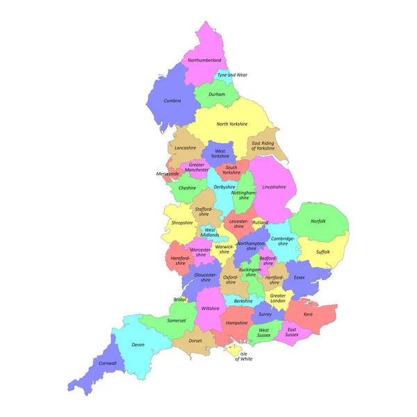
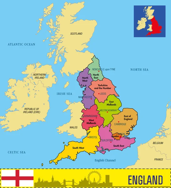
High Quality Colorful Labeled Map Of England With Borders Of The Counties

Vector, 3MB, 4000 × 4000 eps
stock vector Northern Midlands (Tasmania) outline map set

Northern Midlands (Tasmania) Outline Map Set

Vector, 1.38MB, 6000 × 3000 eps
stock vector Outline vector map of the six metropolitan counties of England, United Kingdom

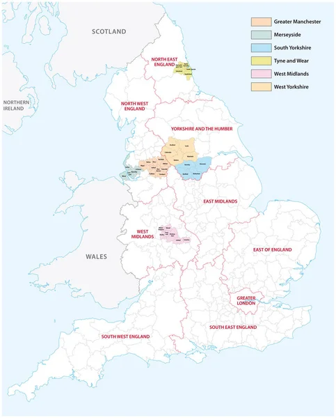
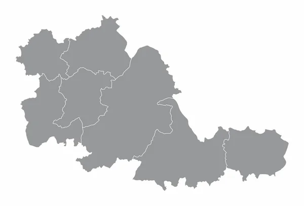
Outline Vector Map Of The Six Metropolitan Counties Of England, United Kingdom

Vector, 2.31MB, 3575 × 4440 eps
stock vector England ceremonial counties vector map colored by regions

England Ceremonial Counties Vector Map Colored By Regions

Vector, 9.96MB, 7292 × 7292 eps
stock vector Map of East Midlands England

Map Of East Midlands England

Vector, 9.41MB, 7006 × 6706 eps
stock vector City map Birmingham, travel vector poster design

City Map Birmingham, Travel Vector Poster Design

Vector, 8.41MB, 5715 × 8001 eps
stock vector Color vector illustration, United Kingdom Regions Map

Color Vector Illustration, United Kingdom Regions Map

Vector, 5.24MB, 6496 × 4313 eps
stock vector Political map of United Kingdom with regions and their capitals

Political Map Of United Kingdom With Regions And Their Capitals

Vector, 2.43MB, 6000 × 5729 eps
stock vector Political map of United Kingdom with regions and their capitals

Political Map Of United Kingdom With Regions And Their Capitals

Vector, 1.02MB, 6000 × 6000 eps
stock vector Political map of United Kingdom with regions and their capitals

Political Map Of United Kingdom With Regions And Their Capitals

Vector, 2.5MB, 6000 × 6405 eps
stock vector Political map of England with regions and their capitals

Political Map Of England With Regions And Their Capitals

Vector, 2.43MB, 5500 × 6050 eps
stock vector West Midlands county divided in districts with labels, England

West Midlands County Divided In Districts With Labels, England

Vector, 8.22MB, 5000 × 3398 eps
stock vector vector map of England ceremonial counties. Flag of England. Navigation and location icons

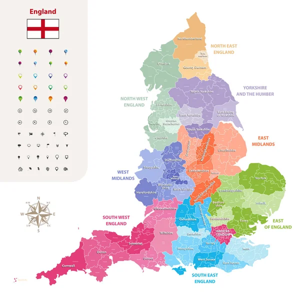
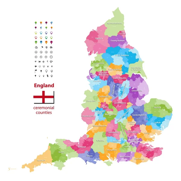
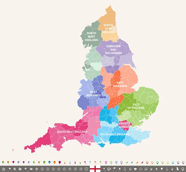
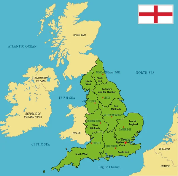
Vector Map Of England Ceremonial Counties. Flag Of England. Navigation And Location Icons

Vector, 9.37MB, 7292 × 7292 eps
stock vector Southern Midlands (Tasmania) outline map set

Southern Midlands (Tasmania) Outline Map Set

Vector, 1.1MB, 6000 × 3000 eps
stock image Flag of Northamptonshire in England

Flag Of Northamptonshire In England

Image, 7.26MB, 4288 × 2848 jpg
stock vector England ceremonial counties and their districts vector map. Each county distinctions between each other by different color palette

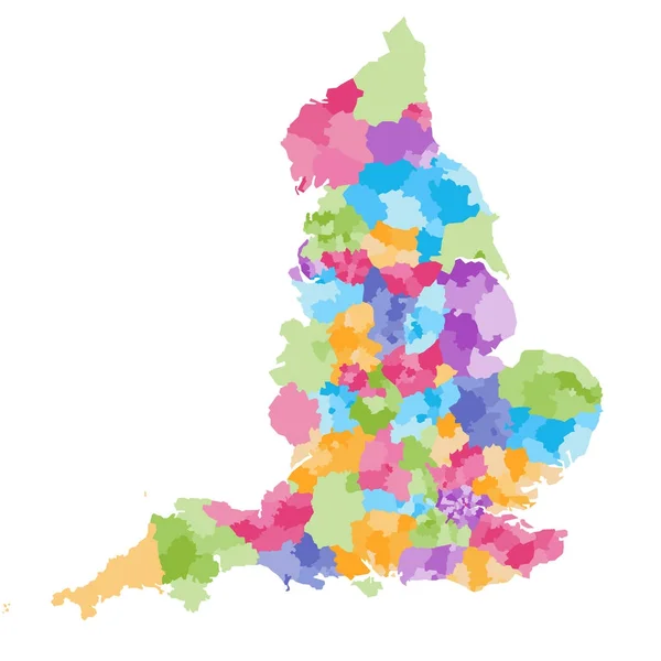
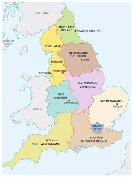
England Ceremonial Counties And Their Districts Vector Map. Each County Distinctions Between Each Other By Different Color Palette

Vector, 5.73MB, 7292 × 7292 eps
stock vector Political map of England with regions and their capitals

Political Map Of England With Regions And Their Capitals

Vector, 2.43MB, 5500 × 5438 eps
stock vector West Midlands county administrative map isolated on white background, England

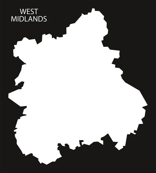
West Midlands County Administrative Map Isolated On White Background, England

Vector, 8.12MB, 5000 × 3398 eps
stock vector outline map of the nine regions of England

Outline Map Of The Nine Regions Of England

Vector, 0.82MB, 3100 × 4130 eps
stock vector Vector map of the regions of the British Isles

Vector Map Of The Regions Of The British Isles

Vector, 1.58MB, 4887 × 7087 eps
Page 1 >> Next