
Stock image Tectonic Plate page 2

Different Types Of Plate Boundaries: Divergent Boundaries, Terrain Section, 3d Render. Tectonic Plates, Side Sliding Margin, Earthquake
Image, 12.36MB, 5511 × 4000 jpg

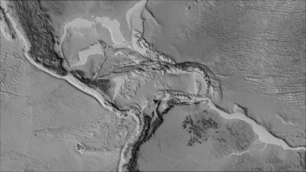
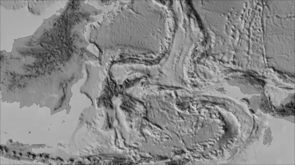
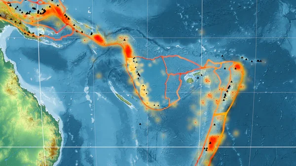
Relief Map Of The Area Around The Molucca Sea Tectonic Plate. 3D Rendering
Image, 4.05MB, 2880 × 1620 jpg
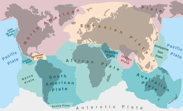
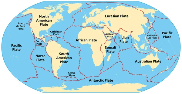
Map Of Earth's Principal Tectonic Plates. Earth's Lithosphere. Major And Minor Plates. Arrows Indicate Direction Of Movement At Plate Boundaries. Vector Illustration
Vector, 3.61MB, 11775 × 7995 eps
Neighborhoods Of The Caribbean Tectonic Plate On The Grayscale Map In The Van Der Grinten I Projection (oblique Transformation). Raw Composite - No Outlines
Image, 2.65MB, 2880 × 1620 jpg
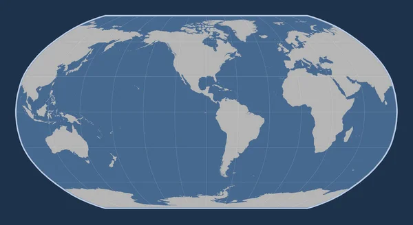
World Solid Contour Map In The Robinson Projection Centered On The 90th Meridian West Longitude
Image, 1.54MB, 4800 × 2625 jpg

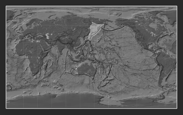
Somalian Tectonic Plate On The Bilevel Elevation Map In The Compact Miller Projection Centered Meridionally.
Image, 7.2MB, 4800 × 3010 jpg

Relief Map Of The Area Around The Pacific Tectonic Plate. 3D Rendering
Image, 5.32MB, 2880 × 1620 jpg
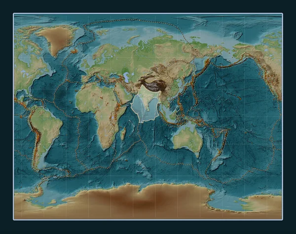
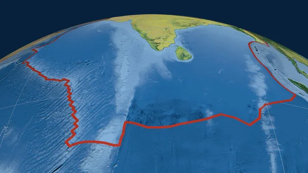
Indian Tectonic Plate On The Wiki Style Elevation Map In The Gall Stereographic Projection Centered Meridionally. Distribution Of Known Volcanoes
Image, 13.86MB, 4800 × 3792 jpg
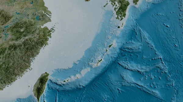
Satellite Map Of The Area Around The Okinawa Tectonic Plate. 3D Rendering
Image, 4.05MB, 2880 × 1620 jpg
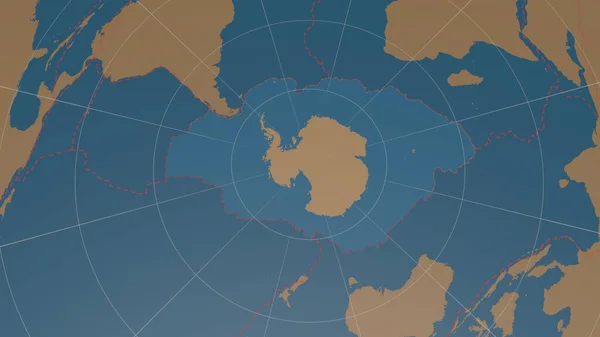
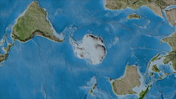
Antarctic Tectonic Plate Overview The Global Shapes Only - Land/ocean Mask In The Azimuthal Equidistant Projection With Dashed Plates Borders. 3D Rendering
Image, 1.56MB, 2880 × 1620 jpg

Antarctica Tectonic Plate Extruded On The Globe. Color Physical Map. 3D Rendering
Image, 3.72MB, 2880 × 1620 jpg
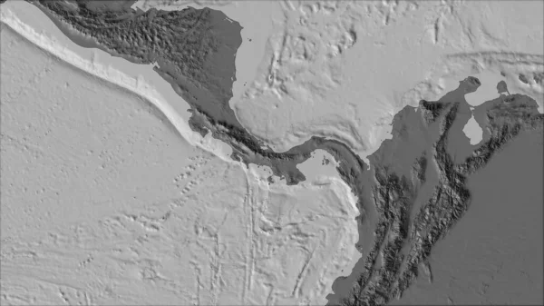
Neighborhoods Of The Panama Tectonic Plate On The Bilevel Elevation Map In The Van Der Grinten I Projection (oblique Transformation). Raw Composite - No Outlines
Image, 2.12MB, 2880 × 1620 jpg
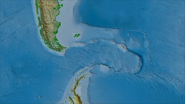
Neighborhoods Of The Scotia Tectonic Plate On The Physical Map In The Van Der Grinten I Projection (oblique Transformation). Raw Composite - No Outlines
Image, 3.92MB, 2880 × 1620 jpg
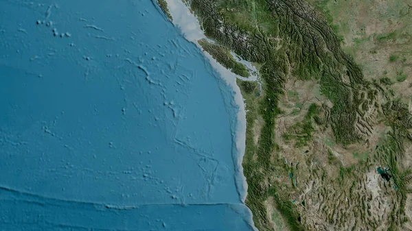
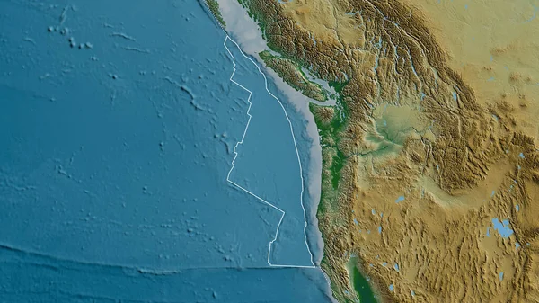
Satellite Map Of The Area Around The Juan De Fuca Tectonic Plate. 3D Rendering
Image, 5.02MB, 2880 × 1620 jpg

Juan De Fuca Tectonic Plate Outlined On The Globe. Topographic Map. 3D Rendering
Image, 4.54MB, 2880 × 1620 jpg
Neighborhoods Of The Antarctica Tectonic Plate On The Satellite B Map In The Van Der Grinten I Projection (oblique Transformation). Raw Composite - No Outlines
Image, 6.47MB, 2880 × 1620 jpg

Niuafou Tectonic Plate Outlined On The Globe. Topography And Bathymetry Colored Elevation Map. 3D Rendering
Image, 2.45MB, 2880 × 1620 jpg
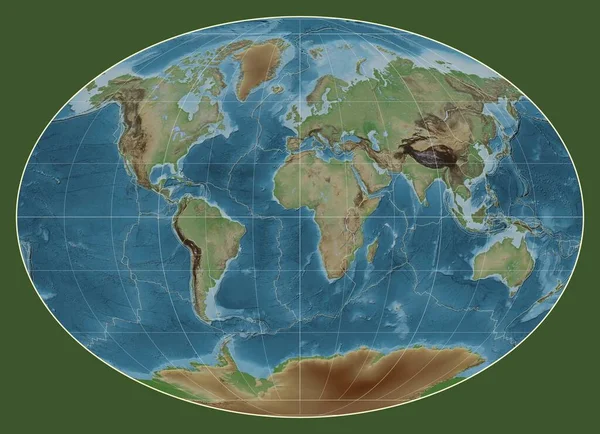
Tectonic Plate Boundaries On A Colored Elevation Map Of The World In The Fahey Projection Centered On The Meridian 0 Longitude
Image, 6.6MB, 3977 × 2880 jpg
Okhotsk Tectonic Plate On The Bilevel Elevation Map In The Compact Miller Projection Centered Meridionally.
Image, 7.21MB, 4800 × 3010 jpg
Indian Tectonic Plate Outlined On The Globe. Topographic Map. 3D Rendering
Image, 3.52MB, 2880 × 1620 jpg
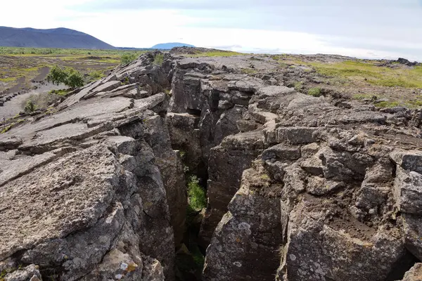
Eurasian And North American Tectonic Plate In Iceland . C9086BD3 High Quality Photo
Image, 15.51MB, 6000 × 4000 jpg

Neighborhoods Of The Molucca Sea Tectonic Plate On The Grayscale Map In The Van Der Grinten I Projection (oblique Transformation). Raw Composite - No Outlines
Image, 2.24MB, 2880 × 1620 jpg

Neighborhoods Of The North Bismarck Tectonic Plate On The Relief Map In The Van Der Grinten I Projection (oblique Transformation). Raw Composite - No Outlines
Image, 3.79MB, 2880 × 1620 jpg

Eurasian Tectonic Plate Outlined On The Globe. Natural Earth Topographic Map. 3D Rendering
Image, 4.55MB, 2880 × 1620 jpg
New Hebrides Tectonic Plate Outlined On The Global Topographic Relief Map In The Mollweide Projection. 3D Rendering
Image, 4.06MB, 2880 × 1620 jpg

North American Tectonic Plate Enlarged, Extruded And Rotated To The West Side The Global Shapes Only - Land/ocean Mask In The Azimuthal Equidistant Projection With Dashed Plates Borders. 3D Rendering
Image, 1.74MB, 2880 × 1620 jpg
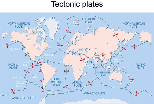
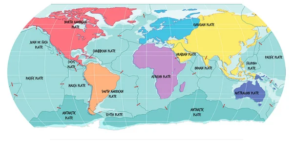
Map Of The Principal Tectonic Plates Of The Earth. The Sixteen Major Pieces Of Crust And Uppermost Mantle Of The Earth, Called The Lithosphere, And Consisting Of Oceanic And Continental Crust. Vector
Vector, 4.27MB, 9000 × 4681 eps
Neighborhoods Of The Scotia Tectonic Plate On The Grayscale Map In The Van Der Grinten I Projection (oblique Transformation). Raw Composite - No Outlines
Image, 2.06MB, 2880 × 1620 jpg
Outline Of The Juan De Fuca Tectonic Plate With The Borders Of Surrounding Plates Against The Background Of A Physical Map. 3D Rendering
Image, 4.92MB, 2880 × 1620 jpg

Pacific Tectonic Plate Outlined On The Global Grayscale Elevation Map In The Kavrayskiy Projection. 3D Rendering
Image, 2.65MB, 2880 × 1620 jpg
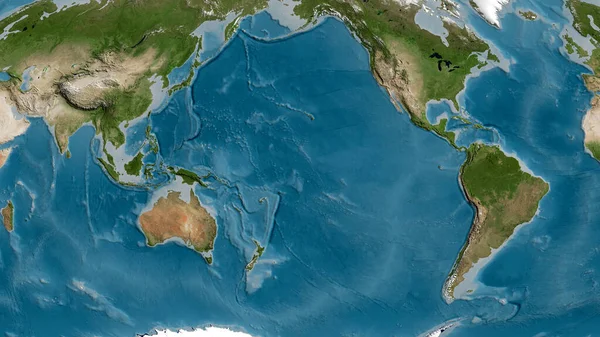
Satellite Map Of The Area Around The Pacific Tectonic Plate. 3D Rendering
Image, 5.12MB, 2880 × 1620 jpg

South America Tectonic Plate Extruded And Presented Against The Global Color Physical Map In The Kavrayskiy Projection. 3D Rendering
Image, 3.54MB, 2880 × 1620 jpg

Outline Of The Burma Tectonic Plate With The Borders Of Surrounding Plates Against The Background Of A Satellite Map. 3D Rendering
Image, 3.58MB, 2880 × 1620 jpg
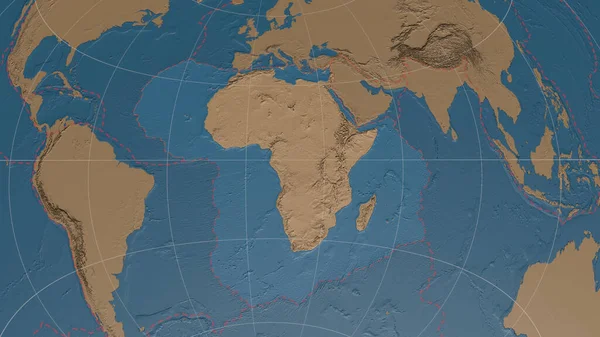
Africann Tectonic Plate Overview The Global Grayscale Elevation Map In The Azimuthal Equidistant Projection With Dashed Plates Borders. 3D Rendering
Image, 3.52MB, 2880 × 1620 jpg

Outline Of The Pacific Tectonic Plate With The Borders Of Surrounding Plates Against The Background Of A Relief Map. 3D Rendering
Image, 5.55MB, 2880 × 1620 jpg

Pacific Tectonic Plate Outlined On The Global Topographic Map In The Kavrayskiy Projection. 3D Rendering
Image, 5.03MB, 2880 × 1620 jpg
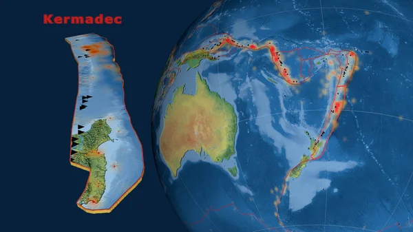
Kermadec Tectonic Plate Described, Extruded And Presented Against The Globe. Natural Earth Topographic Map. 3D Rendering
Image, 3.58MB, 2880 × 1620 jpg

South America Tectonic Plate Extruded And Presented Against The Globe. Grayscale Elevation Map. 3D Rendering
Image, 2.02MB, 2880 × 1620 jpg
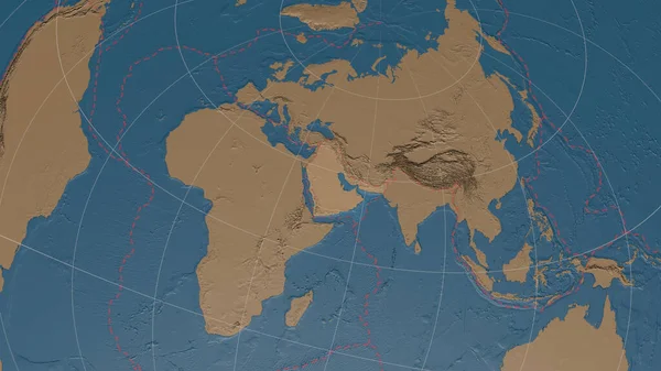
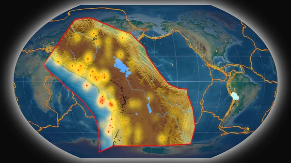
Arabiann Tectonic Plate Overview The Global Grayscale Elevation Map In The Azimuthal Equidistant Projection With Dashed Plates Borders. 3D Rendering
Image, 3.32MB, 2880 × 1620 jpg

Antarctic Plate Shape Outlined On A Darkened And Desaturated Background Of The Satellite Map With Informative Overlays. 3D Rendering
Image, 3.5MB, 2880 × 1620 jpg
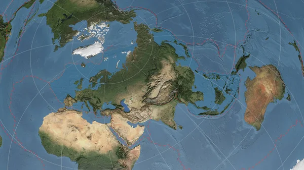
Eurasiann Tectonic Plate Overview The Global Satellite Imagery In The Azimuthal Equidistant Projection With Dashed Plates Borders. 3D Rendering
Image, 4.4MB, 2880 × 1620 jpg

Outline Of The Amur Tectonic Plate With The Borders Of Surrounding Plates Against The Background Of A Pattern Map. 3D Rendering
Image, 4.78MB, 2880 × 1620 jpg

Timor Tectonic Plate Extruded On The Globe. Satellite Imagery. 3D Rendering
Image, 4.03MB, 2880 × 1620 jpg

Philippine Sea Tectonic Plate Outlined On The Global Satellite Imagery In The Kavrayskiy Projection. 3D Rendering
Image, 4.84MB, 2880 × 1620 jpg

Outline Of The Somalian Tectonic Plate With The Borders Of Surrounding Plates Against The Background Of A Relief Map. 3D Rendering
Image, 4.84MB, 2880 × 1620 jpg
Altiplano Tectonic Plate Extruded And Presented Against The Global Color Physical Map In The Kavrayskiy Projection. 3D Rendering
Image, 3.77MB, 2880 × 1620 jpg
Previous << Page 2 >> Next